This exhibition pairs (and compare) painting-journals and prints by James Lancel McElhinney with historical precursors such as William Guy Wall, Jacques-Gerard Milbert, and Samuel Colman. McElhinney considers research, travel, writing and drawing as integral to his artistic practice. Inspired by explorer-artists and naturalists such as Jacques le Moyne, John White, Joshua Rowley Watson, Pavel Svin’in, John-James Audubon, George Catlin, Richard and Edward Kern, Seth Eastman, Frederic Edwin Church, Albert Bierstadt, Thomas Moran and Auguste Morisot, McElhinney has reinvigorated the historic expeditionary practice of topographical sketchbook-painting.
Exploring the Hudson, and other American rivers, McElhinney’s theoretical approach was formed in part by the writings of J.B. Jackson, John Burroughs, and a belief that deeper engagement with nature can lead a distracted society toward a more sustainable future, based on environmental responsibility. This exhibition will be presented simultaneously with Another Way of Looking at Love, photographs by Janelle Lynch. On November 16, 2019, Hudson River Museum will present Thomas Cole’s Refrain: Paintings of Catskill Creek. The show remains on view through February 23, 2020.
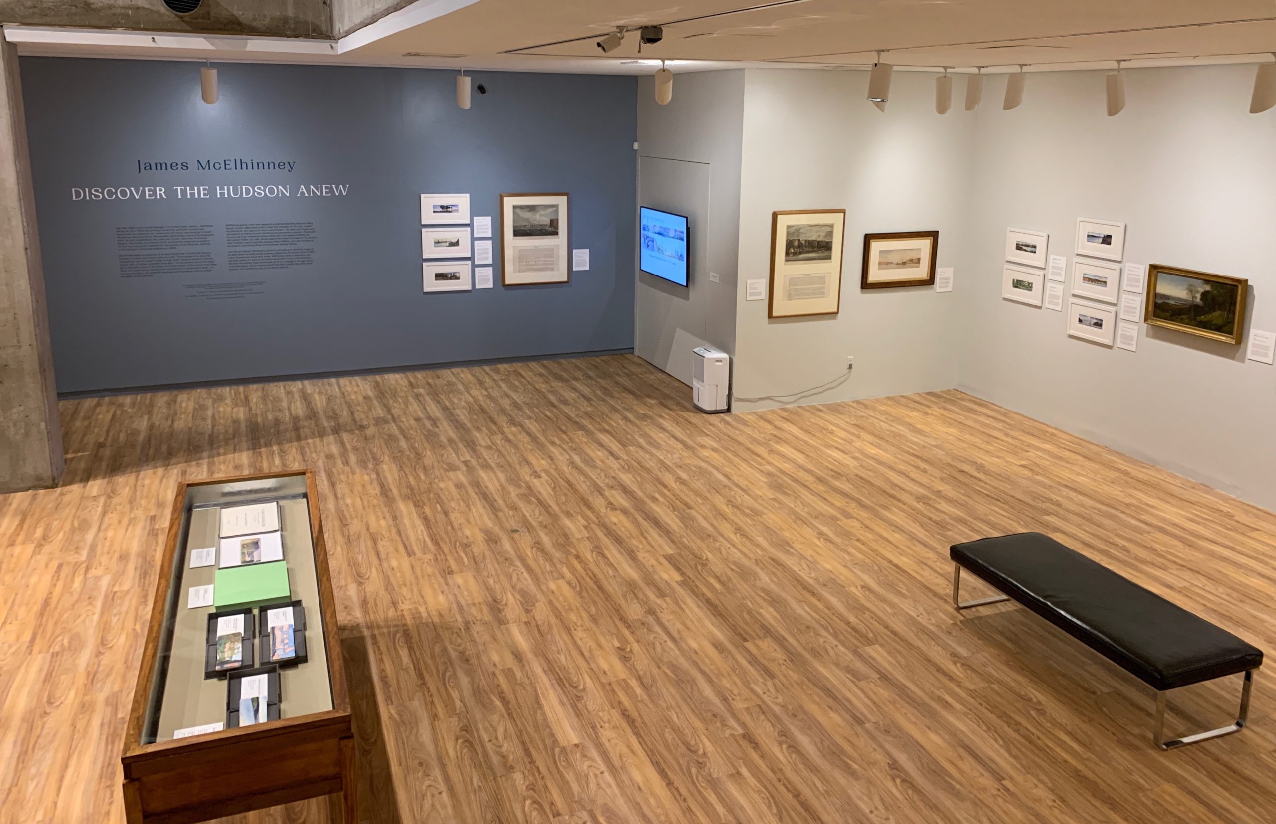
The centerpiece of the show is a visual conversation between Irish-born landscape painter William Guy Wall (1792-1864), and Irish-American artist and author James Lancel McElhinney (1952-). While McElhinney had not formulated his project based on Wall’s travels, he often found himself retracing his footsteps, and those of other 19th-century predecessors like Jacques-Gerard Milbert, Thomas Cole, Samuel Colman and Benson J. Lossing. Below is a look inside the exhibition. Highlights of what is on view. (c) James L. McElhinney 2019
Prints produced by Brilliant Graphics. 300 Eagleview Boulevard. Exton, PA 19341
Works below are drawn from McElhinney’s Hudson Valley Sketchbook (2014-2017), and Wall’s Hudson River Portfolio (1821-1825).
Prints
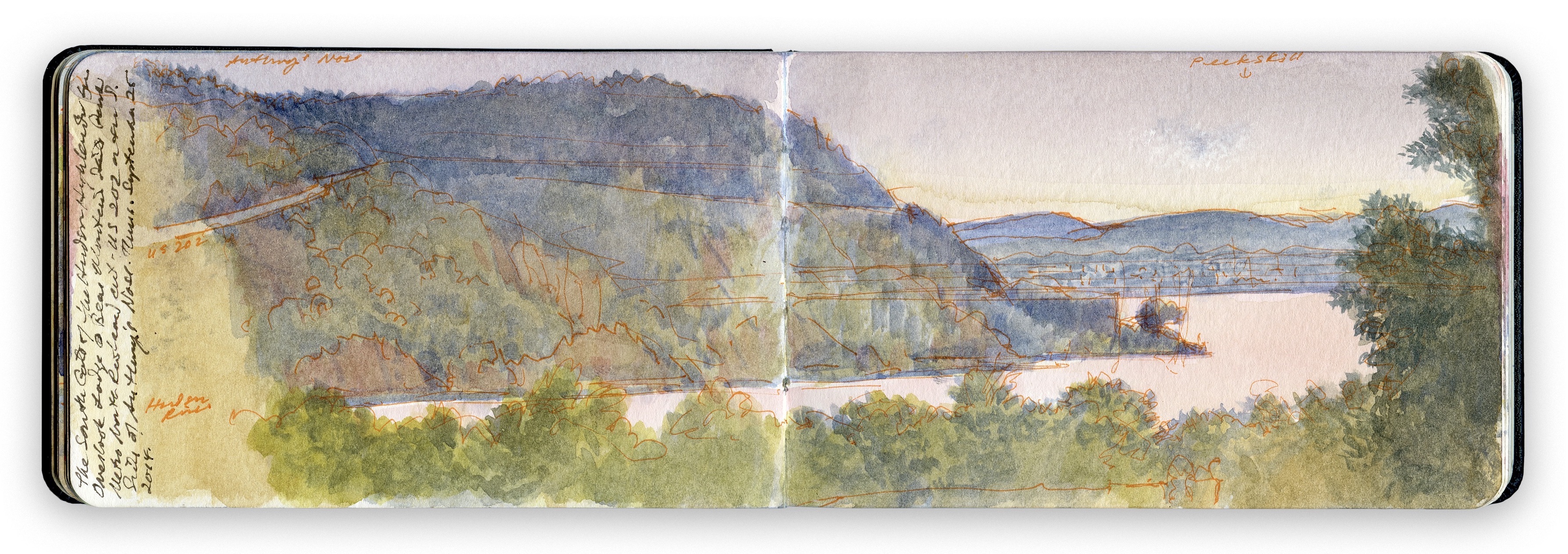
1. SOUTH GATE FROM BEAR MOUNTAIN
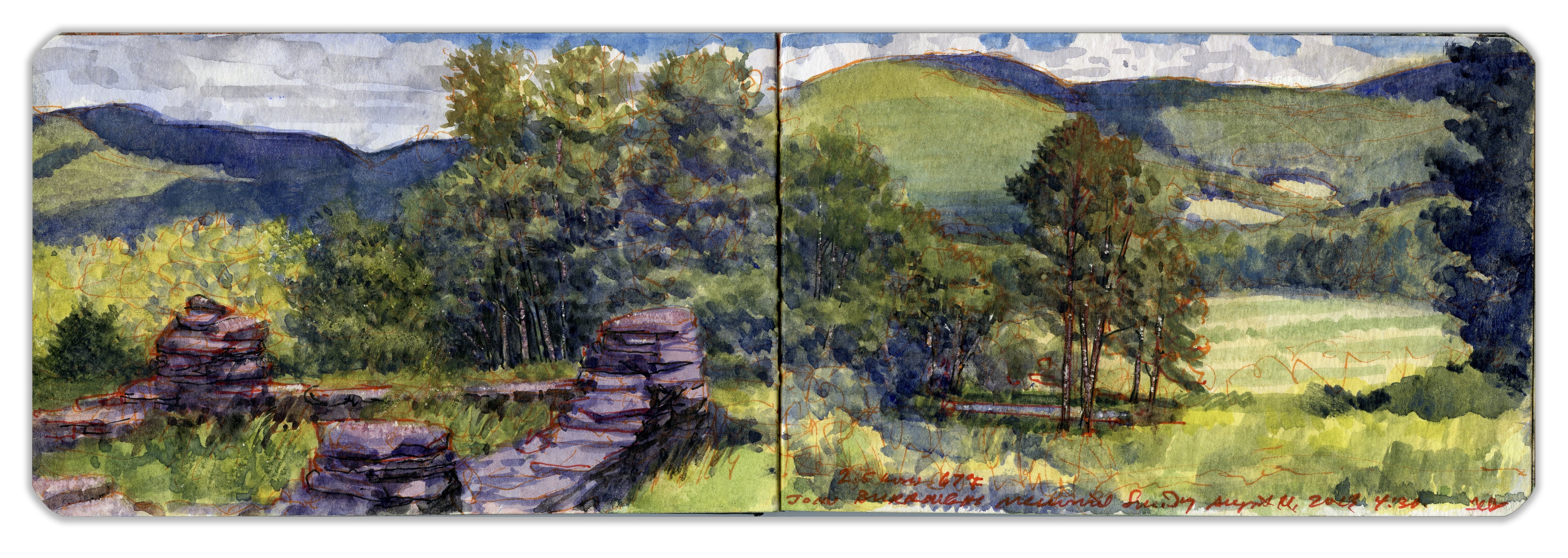
Bending around Trophy Point, the Hudson follows a straight course for several miles, passing Buttermilk Falls and a small island known as Con Hook below the guns of Fort Montgomery on a bluff just north of where Popolopen Creek spills into the river. It was here that American Revolutionary War forces stretched a heavy iron chain across the river, below the mountain known as Anthony’s Nose. Connecting its vertiginous western face to Fort Clinton—Fort Montgomery’s twin—on the bluff south of Popolopen Creek is the Bear Mountain Bridge. Here the banks of the river widen again. A railway runs along a levee enclosing an arm of the river that has become marshland over the years. The tracks cross Iona Island, which served as a naval weapons’ depot during the twentieth century. Parts of the rocky islet remain off-limits to the public. To the south, reaching eastward, is Dunderberg Mountain, or Thunder Hill, the downriver side of the south gate to the Hudson Highlands. Forming the northern gatepost is Roa Hook, below the southern declivity of Anthony’s Nose. Cast in shadow, a small concrete structure marks the location in this painting. The view is from the deck of Bear Mountain Inn’s Overlook Lodge, looking southeast toward the city of Peekskill, across the bay that bears its name.
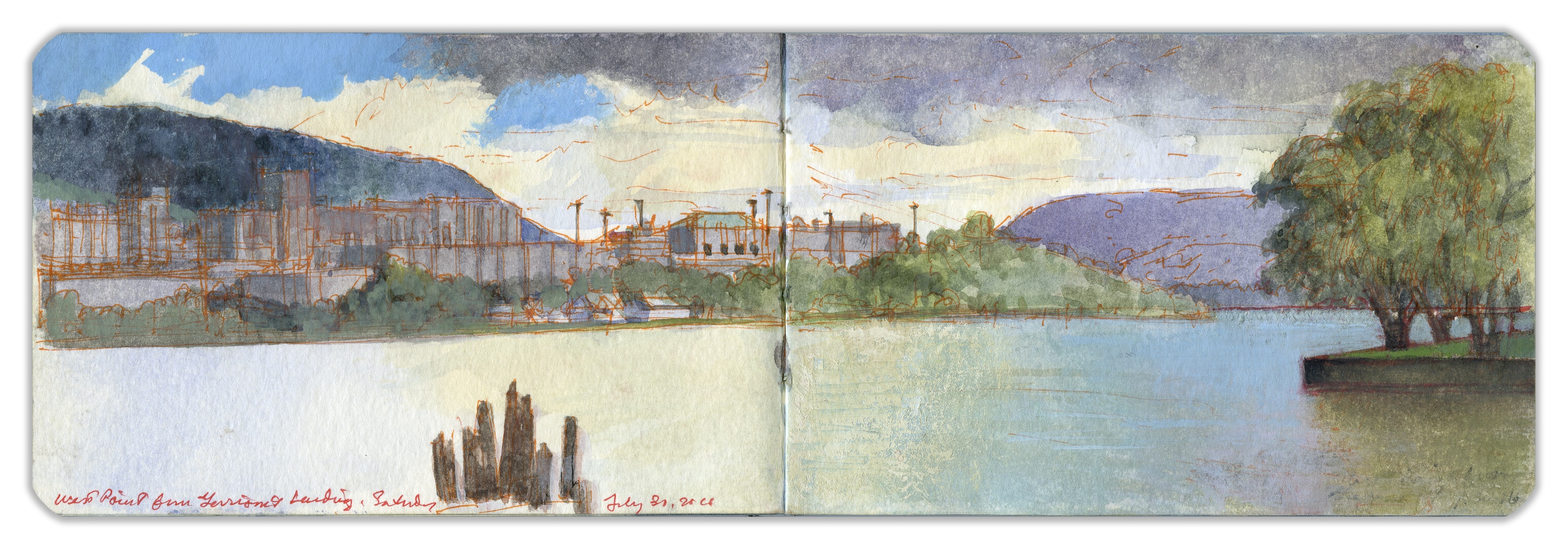
2. WEST POINT FROM GARRISON’S LANDING
When the United States Military Academy at West Point was founded as an engineering school in 1802, the curriculum included topographical drawing and mapmaking. Sylvanus Thayer became superintendent in 1817, expanding the requirement to two hours of daily drawing instruction for second- and third-year cadets. The artwork that launched the Hudson River School was a view of Fort Putnam by Thomas Cole, painted in 1826. West Point quickly became a magnet for artists such as George Catlin, William Bartlett, Benson Lossing, William Guy Wall, John Frederick Kensett, and many others looking for picturesque subjects. Academy graduate and noted ethnographic artist Seth Eastman served as interim head of the drawing academy prior to the arrival in 1834 of painter Robert W. Weir, whose forty-two-year tenure transformed the program. One of Weir’s cadets became the celebrated artist James McNeill Whistler. Rising above the buildings to the left we find Crow’s Nest Mountain, which served as a target range for cannon tubes produced at West Point Foundry in Cold Spring, a few miles to the north. A casual observer might fail to realize that what they behold is not just a scenic vista but a key location in American history—a center of science, technology, and art that was to the nineteenth century what Los Alamos was to the 1940s, traversed by a watery thoroughfare.
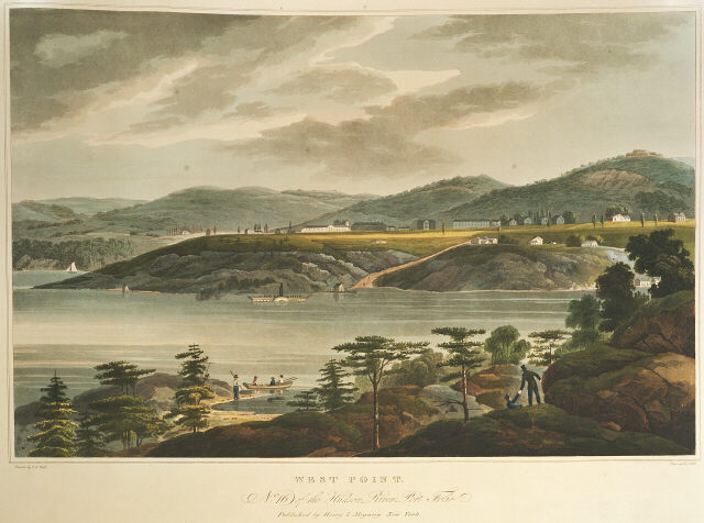
Hudson River Portfolio. West Point. William Guy Wall. Hand-colored aquatint by John Hill. Published by Henry Megary. 1821-1825. Text by John Agg (below)
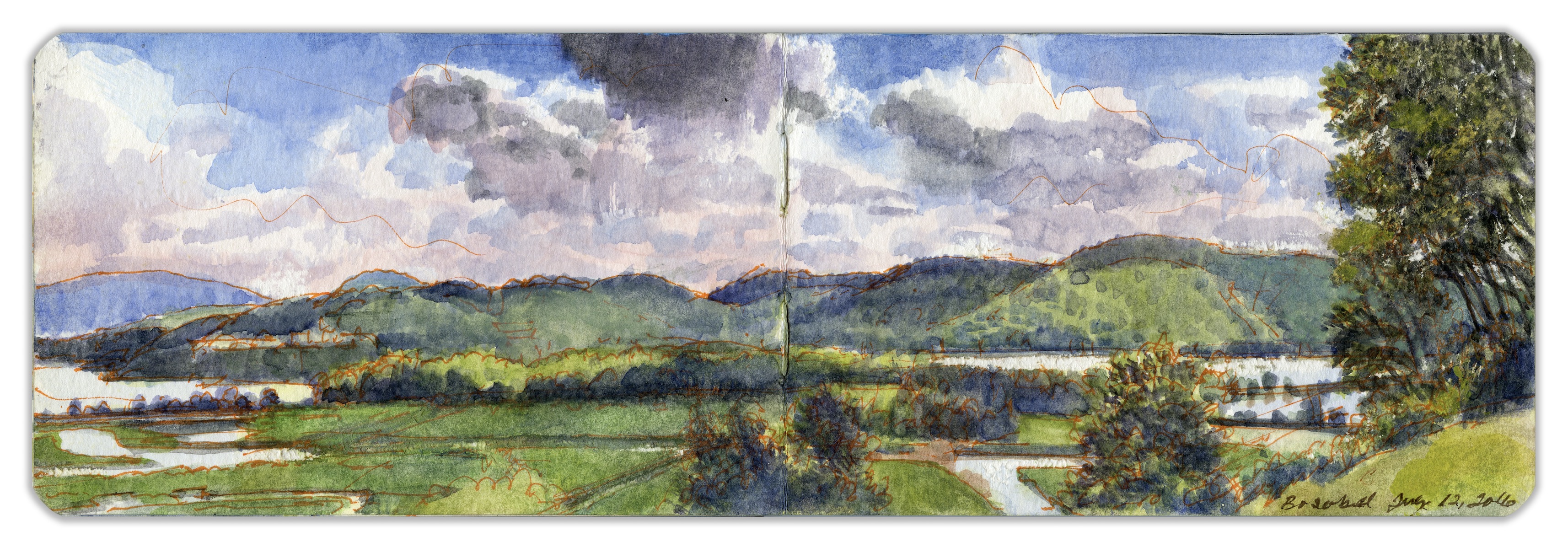
3. LOOKING SOUTH FROM BOSCOBEL
Famed as one of America’s scenic treasures, the Hudson Highlands were shaped by the river carving a path through an outcropping of basement rock extending northward from the Reading Prong of Pennsylvania and the Ramapo Mountains of northern New Jersey. The waterway variously known as Muhheahkunnuck, North River, and Hudson’s River has been a thoroughfare since the dawn of human habitation. Rising in the Adirondack Mountains, the river flows more than three hundred miles to its confluence with the Atlantic. In the early nineteenth century, more than three hundred commercial vessels plied the waters daily between Troy and New York City. On September 14, 1608, the Half Moon dropped anchor in these waters. Writing in his journal on September 14, 1609, Robert Juet described the setting: “The Land grew very mountainous. The River is full of fish.”
On September 25, 1780, Benedict Arnold boarded the Swan-class war sloop H.M.S. Vulture in these very waters. Traversing the foreground is the Hudson Line railway. The marshlands created when the railroad was built in 1851 were briefly converted to rice paddies, but the scheme failed. In the foreground to the right is Constitution Island, with West Point on the far shore. This vista from Boscobel House and Gardens in Garrison, New York, attracts thousands of visitors every year.
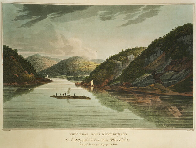
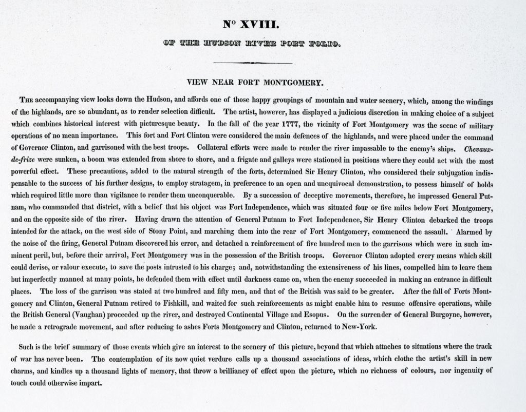
Hudson River Portfolio. View Near Fort Montgomery. William Guy Wall. Hand-colored aquatint by John Hill. Published by Henry Megary. 1821-1825. Text by John Agg (below)
4. THE WESTERN HIGHLANDS FROM BOSCOBEL
To the southwest, the orderly divisions of Constitution Marsh become apparent. Channels were cut through the marshland during the second quarter of the nineteenth century for the cultivation of wild rice. The blue summit at left is Bear Mountain. The gray dashes in the foliage above the river are the stone buildings of West Point. Enclosed by the Hudson Line causeway to the right is Foundry Cove, which is fed by Indian Brook. By the late twentieth century, industrial waste had resulted in the Hudson having the greatest concentration of cadmium pollution on the planet. Folksinger and activist Pete Seeger conceived the idea of building a replica nineteenth-century gaff-rigged sloop and offering cruises and concerts to promote the rehabilitation of the Hudson Estuary. Public outcry led Consolidated Edison to abandon plans for a massive hydroelectric facility that would have cut into the north slope of Storm King Mountain, several miles upriver. The land is now a state park. Constitution Marsh is today a wildlife refuge, providing habitat for local waterfowl such as herons and egrets as well as a number of songbirds, migratory birds, and bald eagles. Every June almost one thousand snapping turtles come out of the marsh to lay their eggs. More than forty years later, the sloop Clearwater continues to carry Seeger’s message up and down the river.
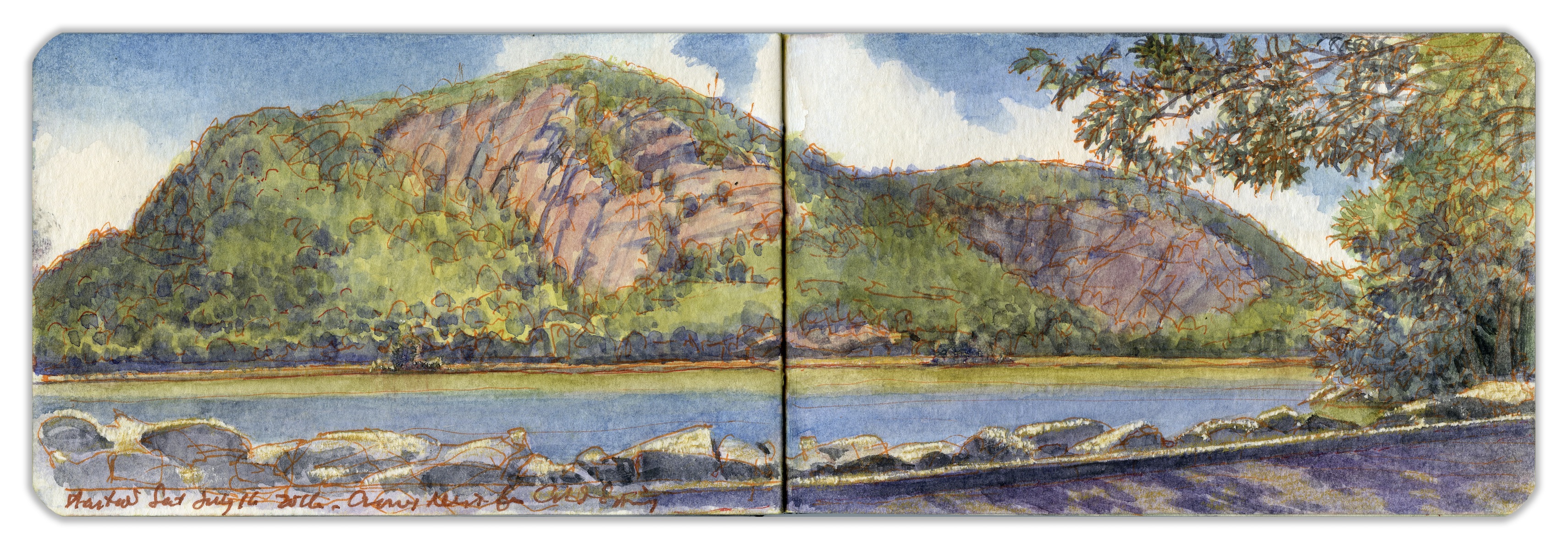
5. CROW’S NEST MOUNTAIN FROM COLD SPRING LANDING
The village of Cold Spring was given its name by George Washington after he refreshed himself at a nearby spring. In colonial times, the village was nothing more than a cluster of buildings by a river landing on the estate of Adolphus Philipse. In 1817 Gouverneur Kemble established the West Point Foundry just south of the village. For nearly a century, as the foundry produced artillery pieces for the United States Army, the village grew into a town. Cannon tubes were finished, inspected, and tested by firing live rounds at Crow’s Nest Mountain, across the river. The rocky slopes are said to be littered with thousands of cannonballs and unexploded ordnance. The infamous pirate William Kidd supposedly buried his loot at Kidd’s Plug, the rocky escarpment at the base of the distant cliffs. Putnam County poet George Pope Morris praised the mountain in verse:
“Where Hudson’s wave o’er silvery sands
Winds through the hills afar,
And Cro’ Nest like a monarch stands
Crowned with a single star.”
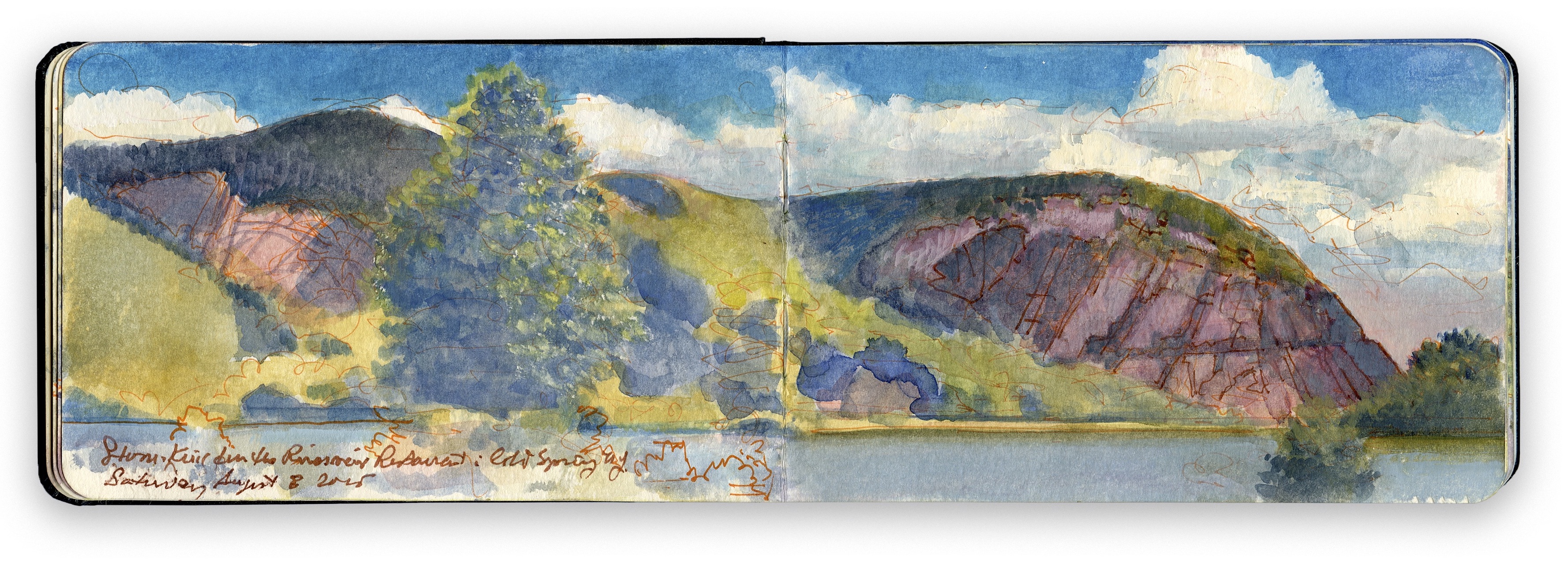
6. CROW’S NEST AND STORM KING
The Dutch named the mountain on the right Boterberg (Butter Hill) because it resembles a butter loaf. Rising more than 1,300 feet above the river, Butter Hill is formed of Proterozoic granite and gneiss distorted by plate tectonics. Its present form was sculpted between 100,000 and 120,000 years ago by glaciation that sheared off its southern slope to expose the rock face visible today. The Hudson Highlands ranks as one of America’s two fjords. The other, Somes Sound at Mount Desert Island in Maine, is where I first witnessed similar evidence of glacial activity smoothing one side of a geological uplift and tumbling down the other. Taking up residence north of Butter Hill, poet and critic Nathaniel Parker Willis named his hilltop estate Idlewild. In an age when explorers crisscrossed the globe naming every rock, tree, and puddle, Butter Hill did not sit well with Willis, who, in today’s parlance, gave it a better brand: “Standing aloft before other mountains in the chain, this sign is peculiar to him. He seems the monarch, and this seems his stately ordering of a change in the weather. Should not STORM-KING, then, be his proper title?”
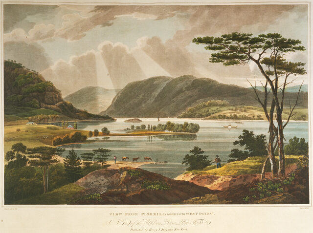
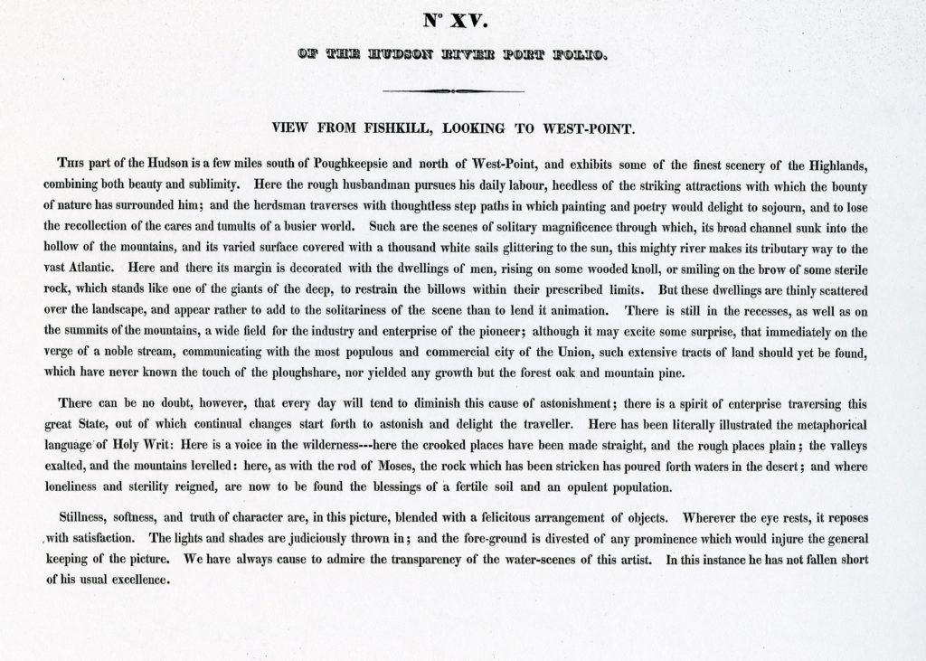
Hudson River Portfolio. View from Fishkill, Looking to West Point. William Guy Wall. Hand-colored aquatint by John Hill. Published by Henry Megary. 1821-1825. Text by John Agg (below)
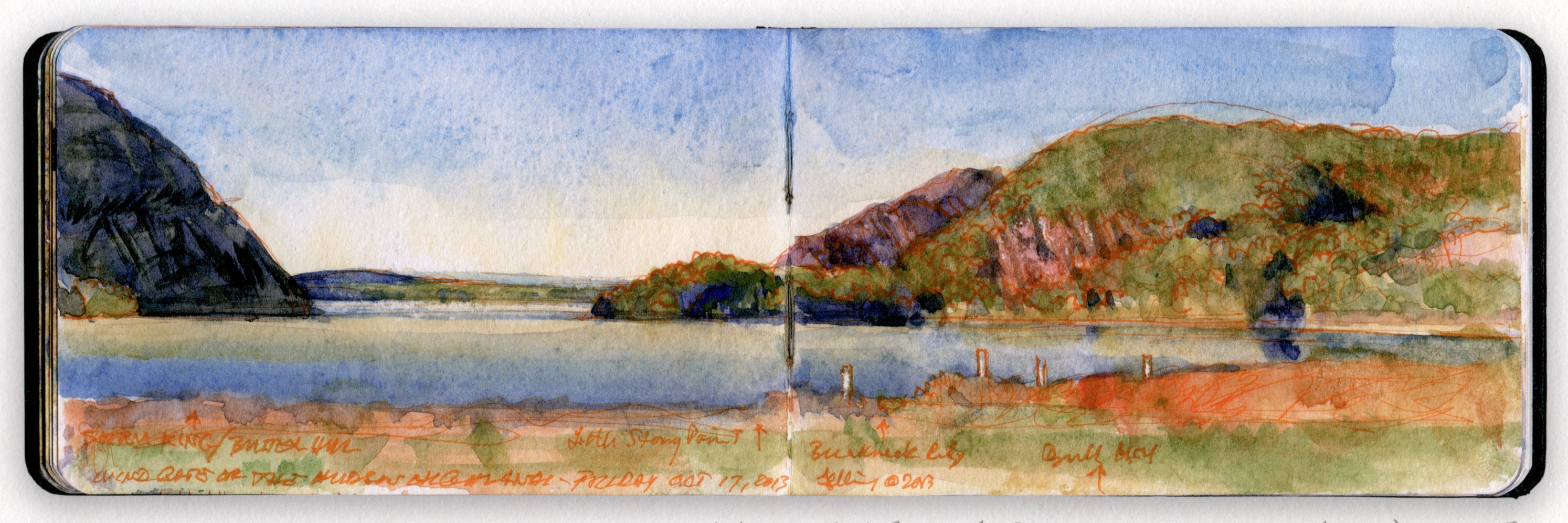
7. WIND GATE FROM COLD SPRING PARK
The North, or Wind, Gate of the Hudson Highlands is formed by Storm King Mountain (Butter Hill) to the west (left) and Breakneck Mountain to the east. In the middle distance is Little Stony Point. On the far shore is the city of Newburgh, where George Washington made his home and headquarters from May 1782 to August 1783. The tranquil cove just north of the landing, juxtaposed against the rugged majesty of these upward-thrusting hills, never fails to surprise and inspire. One can easily imagine Henry Hudson and his crew passing this place, wondering where the river might lead them. In the words of Robert Juet, writing on September 15, 1609:
“The morning was misty until the sunne arose: then it cleared. So wee weighed with the wind at South, and ran up the River twentie leagues, passing by High Mountaines. Wee had a very good depth . . . and great store of Salmon in the River.”
Hudson did not know that at the same time Sieur Samuel de Champlain was exploring the lake that today bears his name and what is now Lake George. Had either party pressed on a little farther, they might have met near Glens Falls.
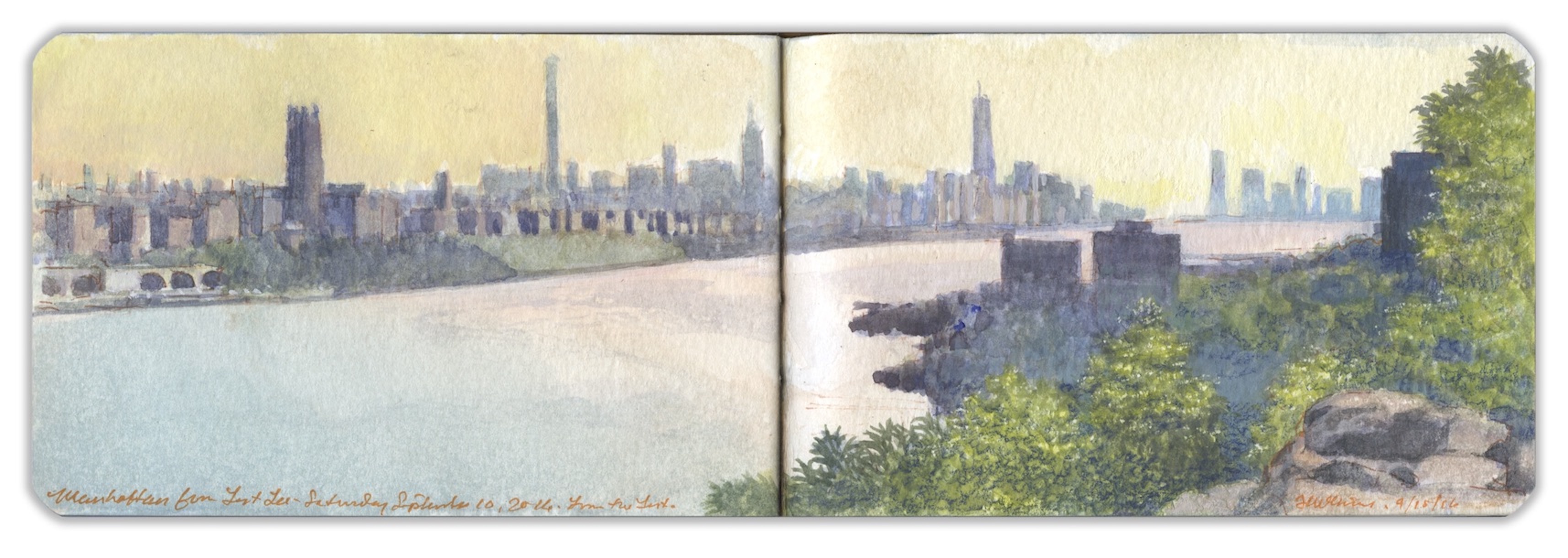
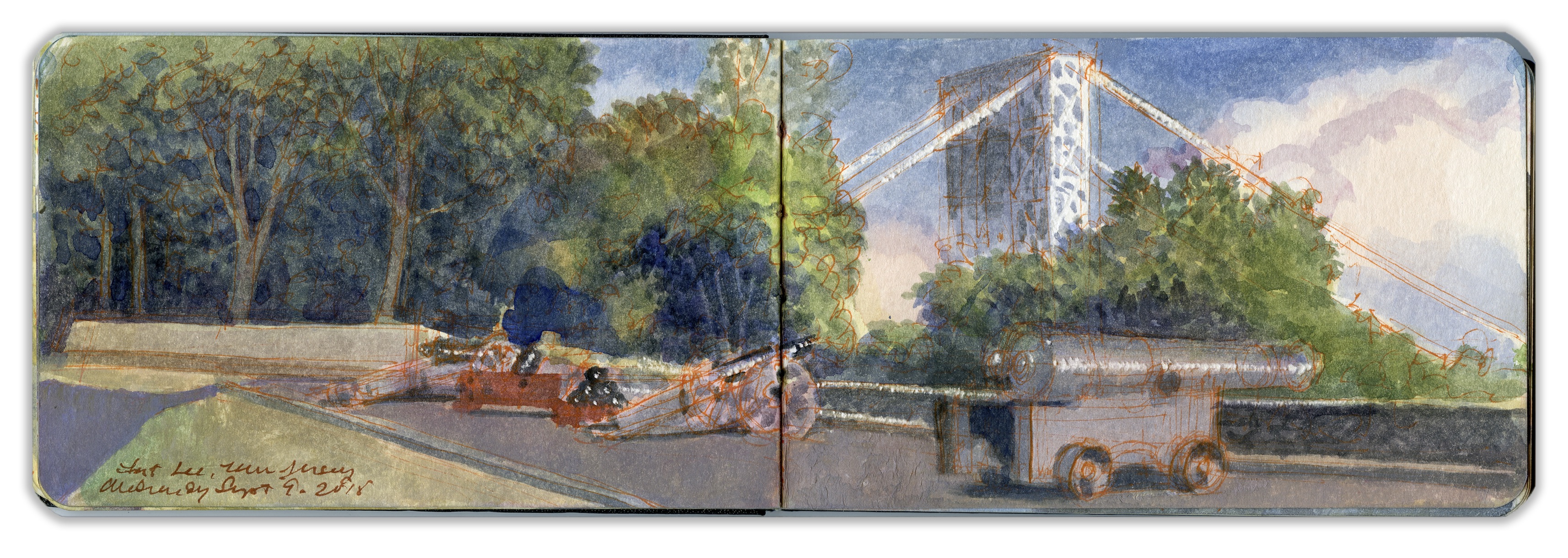
8. LOOKING SOUTH FROM FORT LEE
The Lenni Lenape called the Palisades “Weehawken” (“rocks that look like trees”). On a grassy ledge just north of the western portal of the Lincoln Tunnel, Vice President Aaron Burr mortally wounded former Secretary of the Treasury Alexander Hamilton in a duel fought on July 11, 1804. The site is six miles downstream from this overlook. The southern end of Fort Lee State Park is marked by a steep declivity, a break in the sheer precipice that girds the western bank of river. Across the Hudson, northern Manhattan landmarks such as Riverside Church and Grant’s Tomb are visible, with the towers of Midtown and Lower Manhattan beyond.
A century earlier, Fort Lee had become a major center of motion-picture production. William Fox established Fox Film Corporation in 1915. Young Thomas Hart Benton worked in Fort Lee as a scenic artist. Film crews shot cliffhanger endings along the Palisades for serials like The Perils of Pauline. Despite the sylvan setting, there was a constant roar from the bridge. Clouds rolled in from the west. A soft rain threw the distant skyline out of focus.
9. RECONSTRUCTED BATTERY AT FORT LEE
From Fort Lee, atop the Jersey Palisades, George Washington watched in horror on November 16, 1776, as British and Hessian troops overwhelmed Continentals who had taken cover in Fort Washington, a large earthwork occupying the highest point on the island of Manhattan.
Shortly thereafter, Redcoats led by Charles Cornwallis scaled the Palisades a few miles to the north, intending to trap Washington with a flank attack. Washington executed a brilliant withdrawal across New Jersey and into Bucks County, Pennsylvania. Five weeks later he crossed the Delaware and fell on the Hessian garrison at Trenton, winning a stunning victory for the patriot cause.
Construction of the George Washington Bridge, which opened in 1932, carved a ditch through the basaltic diabase cliffs to accommodate the roadway. In 1937 New York and New Jersey created the Palisades Interstate Park Commission, with Monument Park (Fort Lee) as its southernmost terminus. For the bicentennial of the American Revolution, parking lots and an interpretive center were built. Earthworks were restored to re-create the feeling of an eighteenth-century fort. When I first visited the site, in the 1990s, the fiberglass revetments had faded and were cracking. Recent improvements replaced these with timbers. A blockhouse and cabin were built, along with a coastal battery. On the anniversary of the battle, artillerymen fire salutes from the cannons, rattling Manhattan windowpanes.
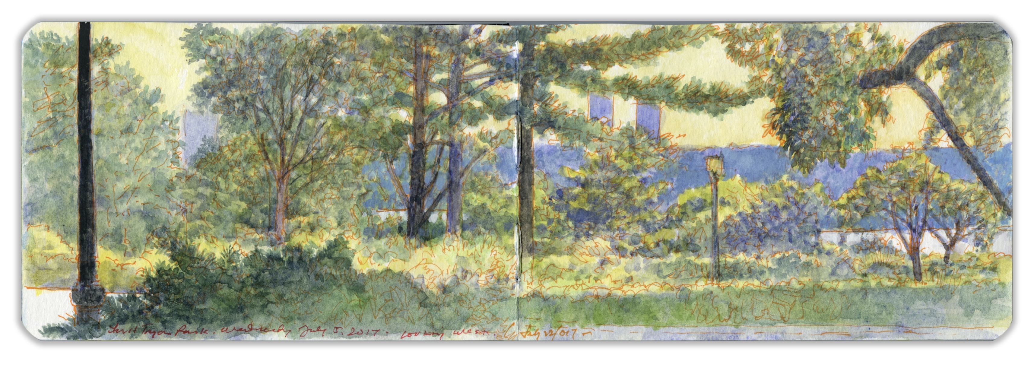
10. THE HEATHER GARDEN, FORT TRYON PARK
Northern Manhattan possesses nearly five hundred acres of parklands, divided primarily between Highbridge Park, Fort Tryon Park, and Inwood Hill Park, along with smaller parks and green spaces scattered across the island above 155th Street. Since the 1970s nonprofit conservancies have played a key role in locating non-government funding for the maintenance and improvement of New York parklands. The New York Restoration Project planted one million trees, making New York one of the greenest cities in the nation. The Heather Garden and Alpine Garden in Fort Tryon Park attract thousands of visitors every year.
Working on this painting one hot summer day, my wife sat beside me, reading a book. Crying out in alarm, she pointed to a small snake writhing on the hot asphalt, being cooked to death under a burning sun. I rushed over, lifted it carefully with the end of my brush, and laid it under a bush. Sprinkling the creature with cool water, I studied its form, the shape of its tiny head, narrow neck, taupe coloring, the paired markings running down either side of its spine. “What are you?” I wondered. And suddenly, I knew. It was a timber rattlesnake. These snakes are not hatched from eggs but born live, a dozen at a time. I wondered. “Where’s your mother? Where’s the rest of your family?” Revived, the little serpent flicked its tongue and disappeared into a stone wall. Botanists John and William Bartram would have approved.
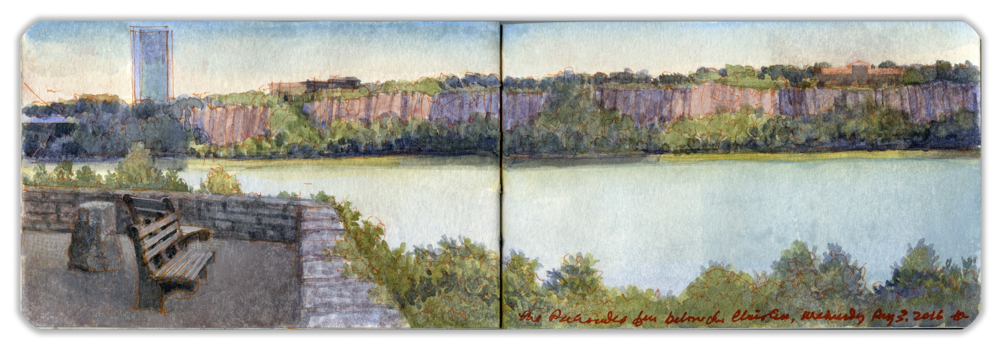
11. THE PALISADES FROM BELOW THE CLOISTERS
Shaded by rocky outcroppings, an esplanade runs along the bluff, offering spectacular views of the Jersey Palisades—a sheer wall of basaltic diabase sill. One hundred yards southeast of this prospect stands The Cloisters—a facility operated by the Metropolitan Museum of Art as a museum of medieval art, comprising reconstructed enclosures, gardens, and chapels collected by sculptor George Grey Barnard that later were acquired by John D. Rockefeller Jr. and reassembled atop North Hill in Washington Heights by architect Charles Collens. The site was previously occupied by an estate owned by industrialist, harness-racing enthusiast, and art collector Cornelius Billings. The rocky, vertiginous terrain known today as Fort Tryon Park is crisscrossed by stairways, trails, woodlands, and clearings laid out by Frederick Law Olmsted Jr. Trails descend to Broadway and Dyckman Street, where pedestrians and bicyclists can access a trail that leads downstream to the Battery. This view is from a ledge on the northwestern shoulder of North Hill, near the site of the advance of Hessians led by Johann Rall on November 16, 1776. Wildlife has returned to the park. While visiting, I have seen various avian species, including bald eagles, as well as woodchucks, skunks, raccoons, and worrisome reptiles.
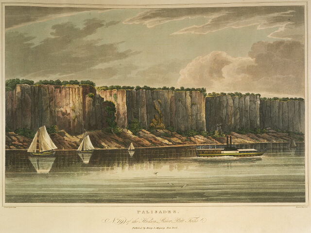
Hudson River Portfolio. The Pallisadoes. William Guy Wall. Hand-colored aquatint by John Hill. Published by Henry Megary. 1821-1825. Text by John Agg (below)
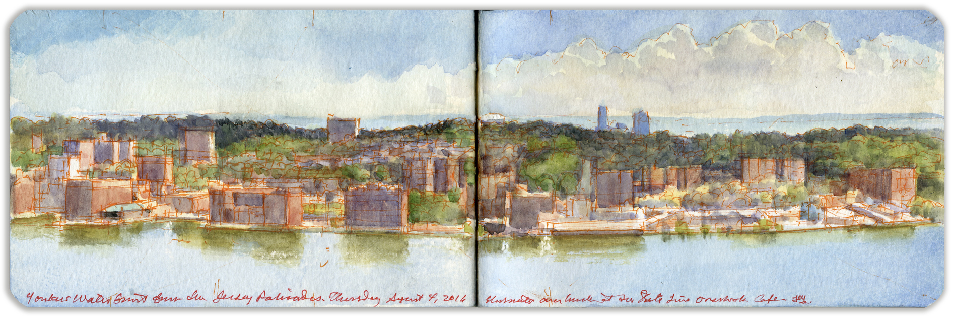
12. YONKERS FROM THE LONG PATH
Stretching from the 175th Street bus station, located at the eastern end of the George Washington Bridge, the Long Path follows historic trails connecting the New Jersey Palisades with the northern Helderberg Mountains west of Albany. Part of the new seven-hundred-mile Empire State Trail, the Long Path follows the rim of the Palisades at its southern end, in the wooded margins between the precipice and Palisades Interstate Parkway. Debouching here and there at scenic parking areas along the motorway, the trail offers stunning vistas of the Bronx and Westchester County. Alpine Scenic Overlook lies directly across the river from Yonkers, established in 1645, when a sawmill was built near the mouth of Nepperhan Creek on land owned by the local Jonkheer (young lord) patroon Adriaen van der Donck.
The village soon grew up around the mill’s river landing, which came to be known as Jonkheers, or Yonkers. During the nineteenth century the town grew into an industrial center, producing goods from firearms to elevators, carpets to Bakelite. With access to both river and rail traffic, the small city prospered. The nation’s first golf course opened in Yonkers. A decline in local industry and a rise in racial tension troubled Yonkers in the last century, but the city is enjoying a renewal, with the redevelopment of the waterfront and other improvements. The Hudson River Museum and Planetarium is located in Trevor Park, in the Glenwood section of northern Yonkers. Seen from a grassy slope below the parking area, the bluffs of Long Island rim the horizon, past the towers of Co-op City on the shores of Pelham Bay.
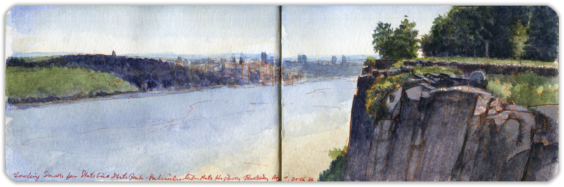
13. LOOKING SOUTHEAST TOWARD YONKERS FROM STATE LINE PARK
The Palisades Interstate Park Commission was created in 1900 by a mutual agreement between the states of New York and New Jersey to preserve the natural environment on the right bank of the Hudson River and to protect the Palisades from being quarried like Hook Mountain, an extension of the same basaltic sill that rises up from the northwestern shores of Tappan Zee. The parklands atop the Palisades are traversed by the historic Long Path, now part of the Empire State Trail. A short distance south of the boundary line between the two states, the trail reaches State Line Overlook, which is also accessible from the northbound lanes of the Palisades Interstate Parkway. A large parking lot serves the café, visitor center, and bookstore. The path at this point is macadamized. Several walled promontories have been built at the very edge of the cliffs. Looking north across the river one finds the village of Hastings-on-Hudson, with Dobbs Ferry beyond. To the south are wooded hills occupied by Lenoir Preserve, Untermeyer Gardens, and Trevor Park. Beyond, the warm tones of the masonry and tall buildings mark the location of downtown Yonkers. Taking note of the number of passing ships and oil barges, I tried to envision the Hudson in 1820, with a quotidian flotilla of several hundred steamboats and sailing vessels plying its waters, a major artery of trade and empire.
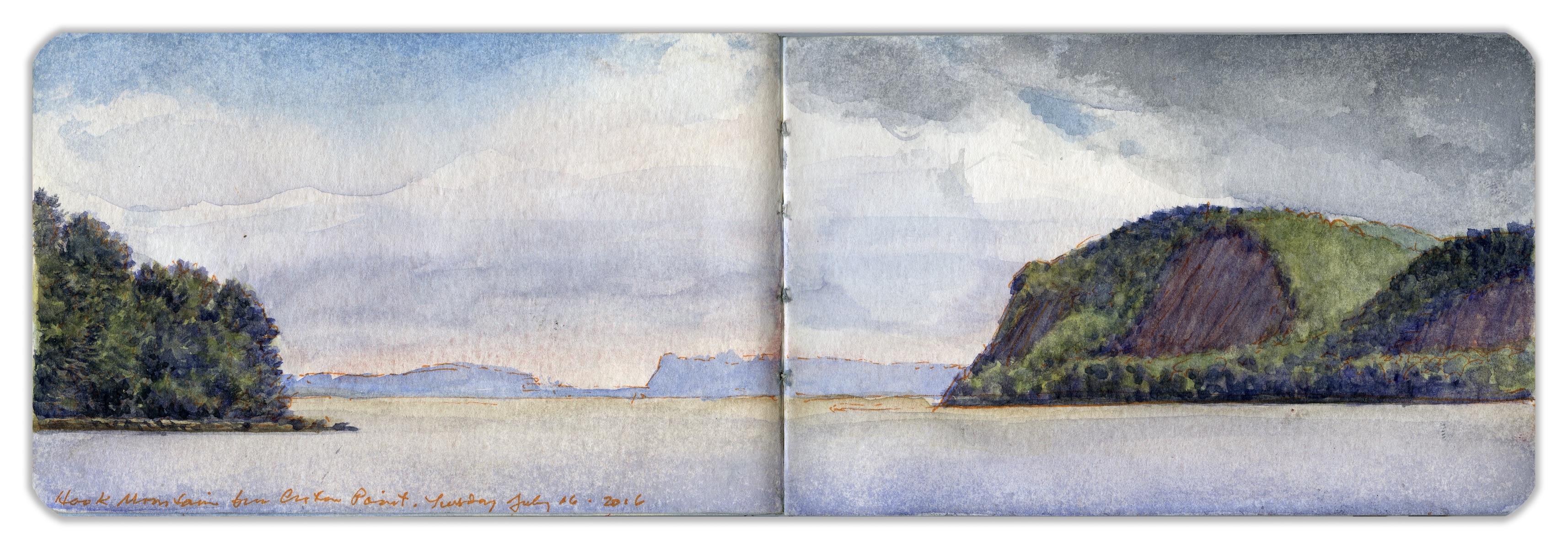
14. HOOK MOUNTAIN FROM CROTON POINT
Extending from Nyack to the Tors towering over West Haverstraw, Hook Mountain is considered part of the Palisades that ends just south of Piermont. The name of this sheer basaltic escarpment crowned by a narrow ridge was inspired by its appearance on maps—an inverted hook, with its point at High Tor.
Located just north of the mouth of Croton River, the hilly peninsula known as Croton Point reaches out from the left bank in a southwesterly direction. Marking the division between Tappan Zee and Haverstraw Bay, the land is maintained by Westchester as a county park. The name is an Anglicization of Kenotin—the name of an indigenous tribal leader who lived near the mouth of the eponymous river during colonial days. The cluster of trees seen to the left is Crawbuckie Park. Far in the distance, across the Tappan Zee, is Tallman Mountain, the northern end of the Palisades. Traveling upriver, the lower Hudson is a series of seas and bays, from Raritan Bay through the Narrows, from the harbor into North River channel. Beyond lies Tappan Zee, Haverstraw Bay, and Peekskill Bay. To be precise, the Hudson is not a river here but a tidal estuary reaching another 130 miles upstream.
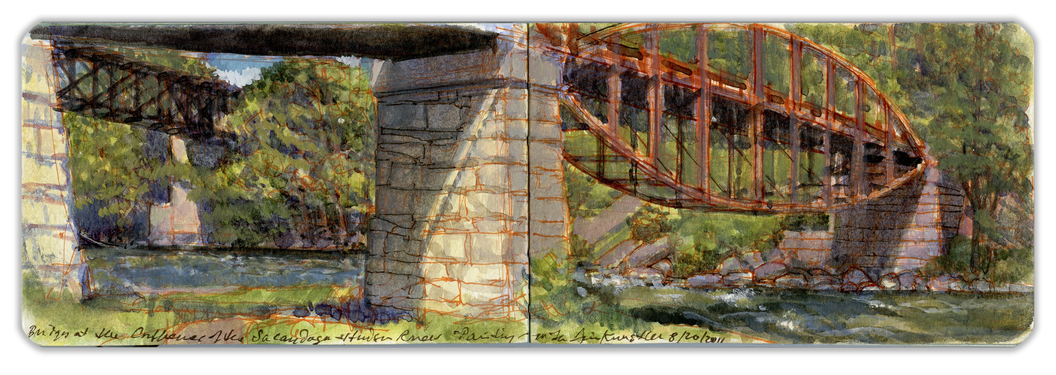
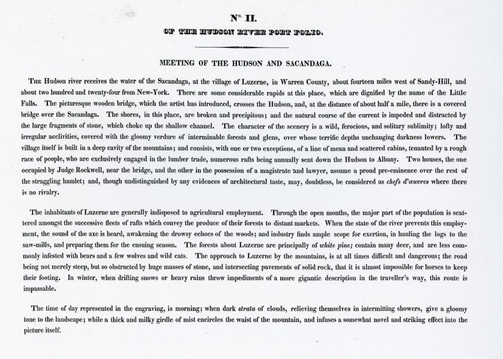
15. BRIDGES NEAR THE MOUTH OF THE SACANDAGA RIVER
Traveling down the Hudson in 1820 with Irish landscape painter William Guy Wall, travel writer John Agg described the land around the mouth of the Sacandaga:
“The shores, in this place, are broken and precipitous; and the natural course of the current is impeded and distracted by large fragments of stone, which choke up the narrow channel. The character of the scenery is a wild, ferocious, and solitary sublimity; lofty and irregular acclivities, covered the gloomy verdure of interminable forests and glens; over whose terrific depths unchanging darkness lowers.”
Visiting the site with author and painter James Howard Kunstler, we found two bridges crossing the Sacandaga. A parabolic lenticular bowstring truss bridge, built in 1885, had replaced the covered bridge seen by Wall and Agg. Falling into disrepair, the bridge was closed to traffic in 1994. Five years later, Saratoga County considered replacing the bridge until preservationists raised funds for its restoration. The bridge reopened to traffic in 2005. Beyond is a deck truss steel bridge, built in 1943. Both spans rest on masonry stone piers. Parking along the shoulder of the Old Corinth Road, we descended a steep embankment and set up on a grassy rise just east of the bridgehead. A few hundred years from the village of Hadley, the setting retained a sense of wildness, save for the Anthropocene geometry of these twin bridges.
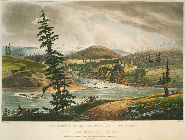
Hudson River Portfolio. Meeting of the Hudson and Sacandaga. William Guy Wall. Hand-colored aquatint by John Hill. Published by Henry Megary. 1821-1825. Text by John Agg (below)
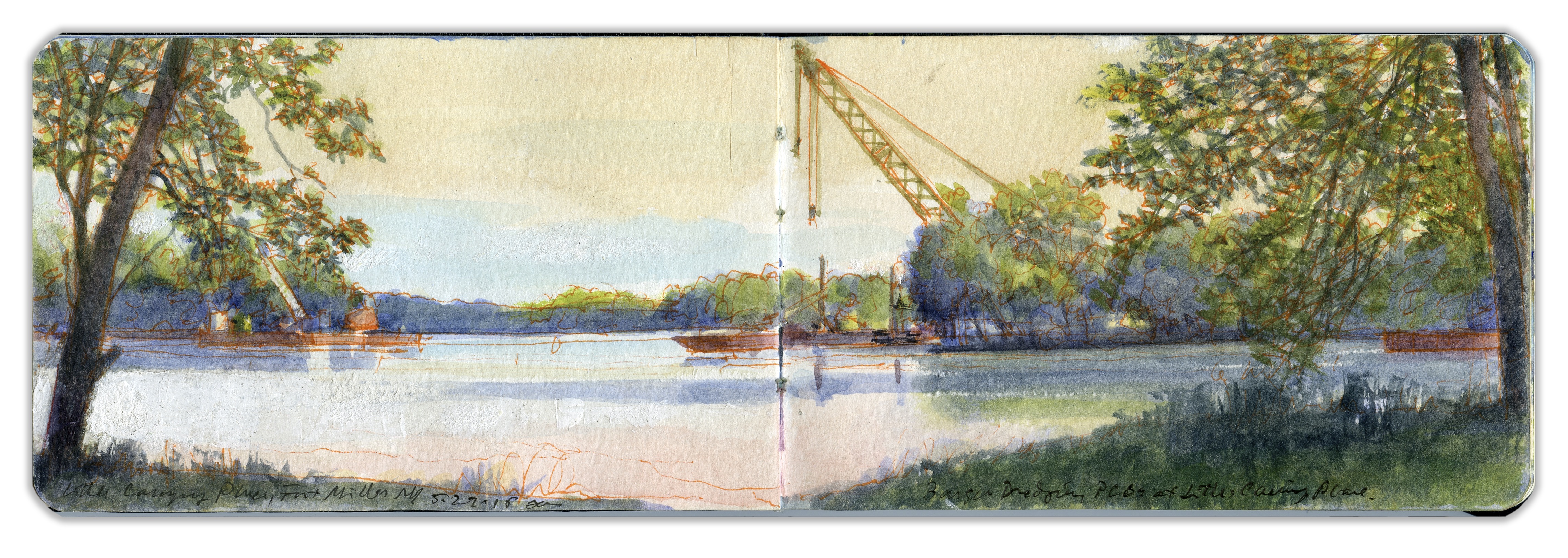
16. VIEW ON THE HUDSON NEAR FORT MILLER
Preparing to produce a series of prints with accompanying texts, Irish painter William Guy Wall journeyed with travel writer John Agg from New York City to the Adirondacks in 1820. Fort Miller had been constructed along the Hudson during the French and Indian War to protect a river crossing, or carrying place, above a small set of falls. The region was famous in the prelude to General Burgoyne’s surrender at Schuylerville, four days and two years before Cornwallis laid down his arms at Yorktown. Burgoyne’s failure brought France into an alliance with the newly formed United States. The area between the Mohawk River and Lake Champlain would soon become well known through the Leatherstocking Tales of James Fenimore Cooper. Now as then, Fort Miller is a pleasant hamlet on the banks of the Hudson, next to one of the locks on the Champlain Canal that links tidewater Hudson to Lake Champlain. Architectural historian, novelist, and raconteur James Howard Kunstler has for many years been a plein-air painting companion. On May 27, 2015, we piled into his pickup truck and headed off in search of a motif. Arriving at Clark’s Mills, discouraged by new fences and threatening signage, we moved upriver to Fort Miller. A pair of dredging barges rides on the stream, cranes at rest, cables slack, these dystopic gatecrashers disrupting pastoral harmony with rusting dissonance remind us that the Hudson is a ongoing concern, a working waterway that mingles beauty with muscle.
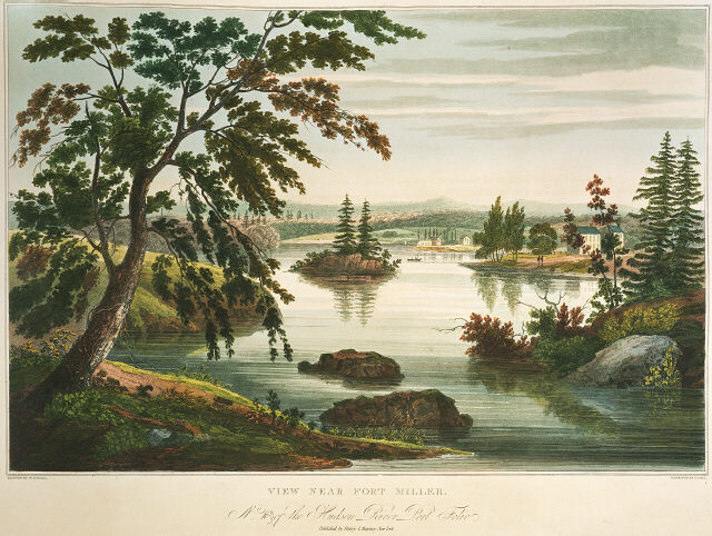
Hudson River Portfolio. View Near Fort Miller Bridge. William Guy Wall. Hand-colored aquatint by John Hill. Published by Henry Megary. 1821-1825. Text by John Agg (below)
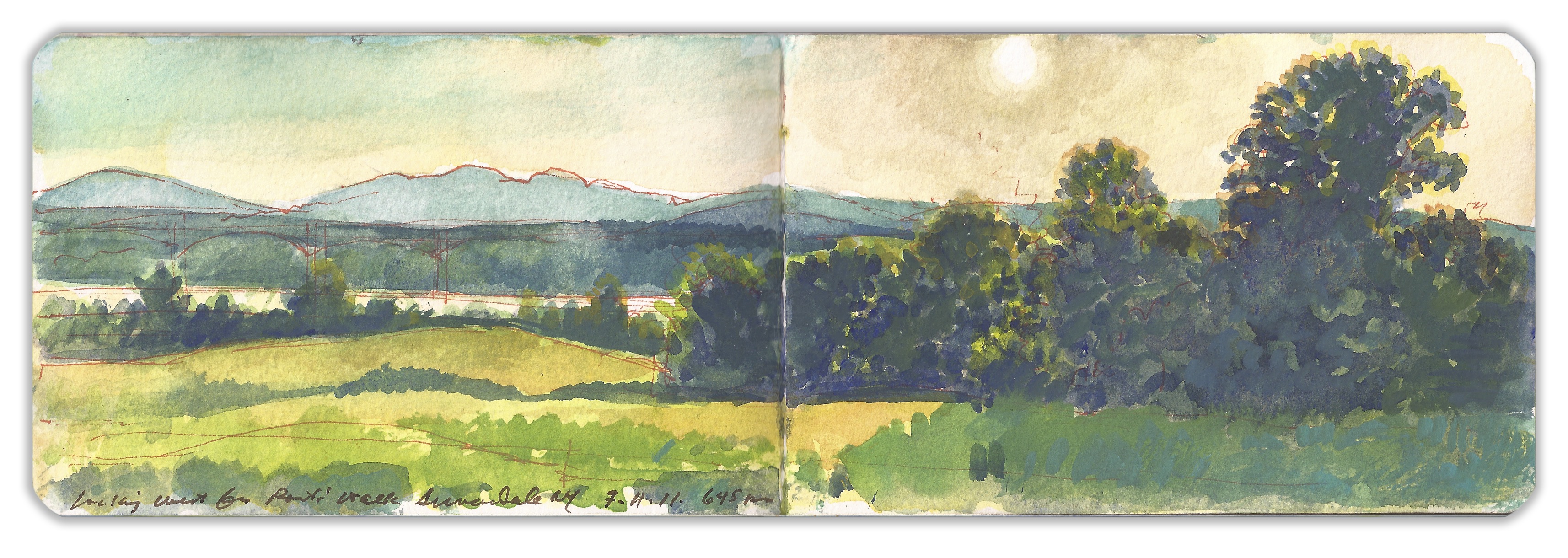
17. LOOKING WEST FROM POETS’ WALK
Located on the left bank of the Hudson a few miles above the Kingston-Rhinecliff Bridge is a rolling tract of land that was first developed into a private pleasure park in 1849. Having built estates atop the bluffs, wealthy families decided to set aside a tract of uncultivated land for the enjoyment of nature and the improvement of health. German landscape architect Hans Jacob Ehler divided the land between clearings and woodlands, laying out trails, view sheds, and pavilions. Washington Irving, William Cullen Bryant, and other notable recipients of Delano and Astor hospitality are said to have drawn inspiration from rambles at Poets’ Walk. In recent years the park has come under the control of Scenic Hudson Land Trust, which maintains the trails and other amenities for year-round public use. Having visited the park on numerous occasions, I have never met hikers on the trails without a pleasant exchange of greetings. Working from one of the wooden benches set out along the trails or from the portable stool strapped to my back, I have never been interrupted or distracted by other visitors. They might slow their pace to steal a glance as they pass by with a nod or a smile. Such places seem to promote civility as much as they inspire bards.

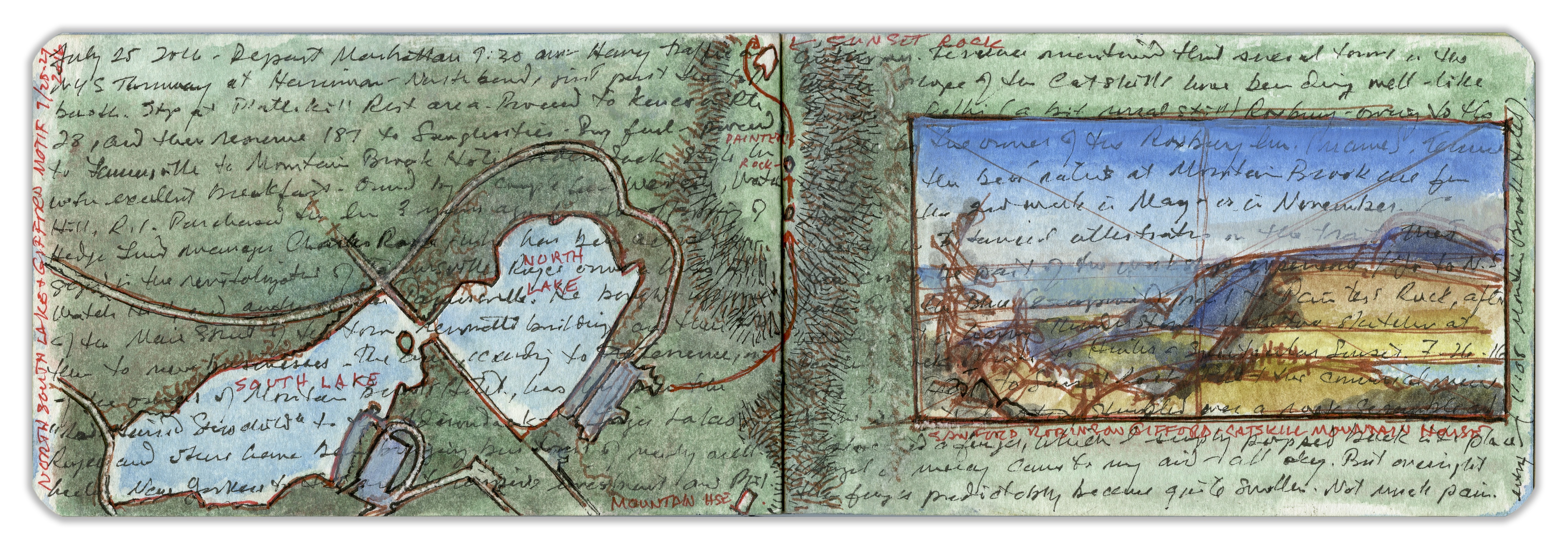
18. PICTORIAL MAP OF NORTH-SOUTH LAKE
Extending westward from the Catskill Escarpment, twin lakes rest in a broad vale between North and South Mountain. On its eastern rim, the site of the Catskill Mountain House is now a wide, grassy ledge. Westward, the land rises toward Tannersville. Before European invaders built settlements in the mountains, indigenous people farmed the bottomlands and hunted game in the heights. Dutch expansion into the region sparked native resistance, which quickly escalated into bloody warfare. Crops were destroyed. Settlements scattered, clearing the way for modern economies. Exploring the mountains in search of new plant species, Philadelphia naturalist John Bartram went to the Catskills in 1753, visiting North-South Lake. Fourteen-year-old Billy had demonstrated a passion for drawing. Attracted to a large tree fungus known botanically as Auricularia auricula-judae, the boy was about to test it with his foot when his father pulled him back, away from a coiled rattlesnake. Despite pleas for mercy from both father and son, their rustic guide slew the creature. Making notes on the site during a visit in 2016, I decided to add a map in overlay. Beside it I drew a thumbnail of Sanford Gifford’s view from Sunset Rock.
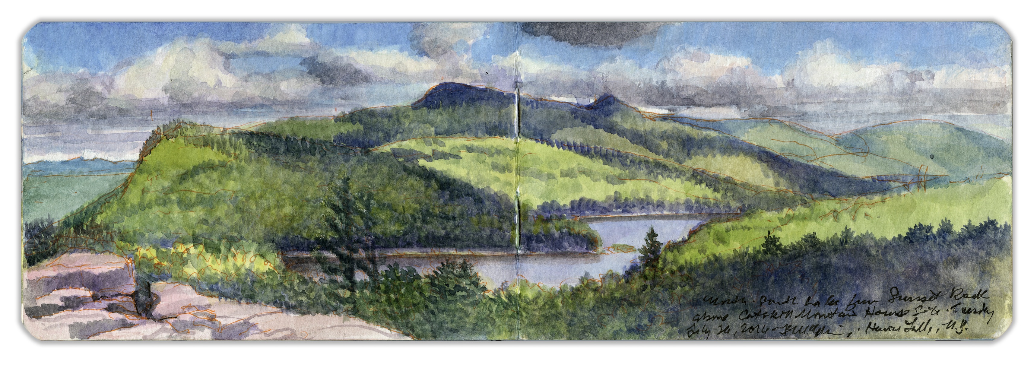
19. NORTH-SOUTH LAKE FROM SUNSET ROCK
On the southeast shoulder of North Mountain, north of the Catskill Mountain House, is an outcropping of exposed rocks interspersed with mostly deciduous trees, mixed with a variety of conifers. The outcropping is approached by a trail that follows the rim of the Catskill escarpment running north from the former site of the Catskill Mountain House—a grand hotel built in 1824 and destroyed by fire in 1963. Halfway along the level part of the trail is a wide stone ledge known as Artist’s Rock, near the brink of a sheer drop of perhaps two hundred feet. From this point the trail rises, traversing rock fall and ledges, requiring hikers to advance hand over hand. The trail continues to climb, finally winding around the foot of a wall of stratified limestone—a former sea floor. The trail ascends above the rim of this formation, entering a wooded understory of ferns and other leafy plants. The Escarpment Trail veers to the left, ascending westward to Newman’s Ledge and the summit of North Mountain. Here the hiker backtracks slightly to the east. Trails climb upward to a rocky clearing, crisscrossed and shattered by deep fissures. Lying at its southwest corner is an object that appears in paintings by Cole, Gifford, and others who took such liberties that one would never know it was the same boulder. Descending the trail, I lost my footing on a rock scramble, dislocating a finger. Without a moment’s thought I popped it back into place and proceeded down the mountain. That evening I painted the sunset from the shore of North Lake. A couple unpacked a tale of being lost overnight on the mountain, with their injured dog, sans food, water, or shelter. Suffering nothing worse than a swollen finger, I felt lucky.
20. JOHN BURROUGHS GRAVESITE
Naturalist John Burroughs (1837–1921) was born near the headwaters of the Delaware River in the western Catskills. He later lived at Slabsides, his woodland refuge near Kingston, New York, in Ulster County. Drawing heavily on travels through the mountainous regions around the Hudson Valley and New England, Burroughs argued that deeper connections with nature would develop the mind and nourish the soul, advocating the practice of close observation. In his essay “The Art of Seeing Things,” published in Leaf and Tendril (1908), Burroughs wrote, “To know is not all; it is only half. To love is the other half.” To a neighbor complaining that birds no longer visited her home, Burroughs replied that during their conversation he had noted the songs of several and named the species one by one. “You must have the bird in your heart,” he told her, “before you can find it in the bush.” Toward the end of his life Burroughs repaired to a rustic farmhouse on a mountainside near his birthplace, Roxbury, New York. He was fond of walking uphill to visit a large recumbent boulder and view of the valley full of memories from his boyhood. There he remains. A fieldstone wall encloses his eternal bed. His wife sleeps beside him.
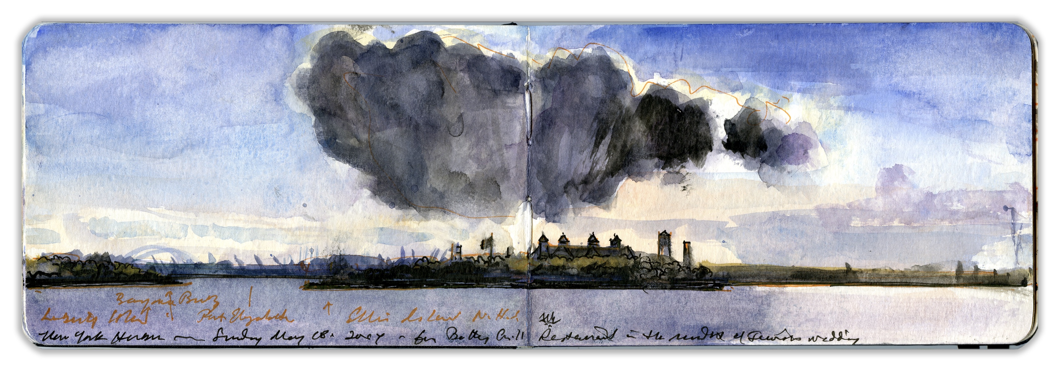
21. ELLIS ISLAND, NEW YORK HARBOR
Ellis Island, also known as Oyster Island, was first fortified in 1795 in preparation for what came to be known as the Quasi-War with France. It was acquired by the federal government in 1808, when a twenty-gun battery was established, which, in concert with the guns of Castle Williams on Governor’s Island and Castle Clinton at the Battery in Lower Manhattan, created a kill zone at the mouth of the Hudson River. While it saw no action during the War of 1812, the island served as a prisoner-of-war camp during the conflict. In 1861 Fort Gibson was decommissioned and repurposed as a naval weapons depot. By 1890 the flood of immigration into New York City had far exceeded the capacity of Castle Garden. A new immigration inspection station opened its doors in 1892. Ellis Island remained in service until 1954. More than twelve million arrivals passed through its gates to become permanent residents and citizens of the United States. Today the site is part of Statue of Liberty National Monument and is accessible only by water. This painting was made in Battery Park, looking across New York harbor, from beside the East Coast Memorial honoring members of the U.S. Merchant Marine and Army Transport Service who perished in coastal waters during World War II.
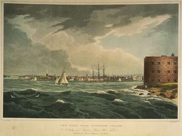
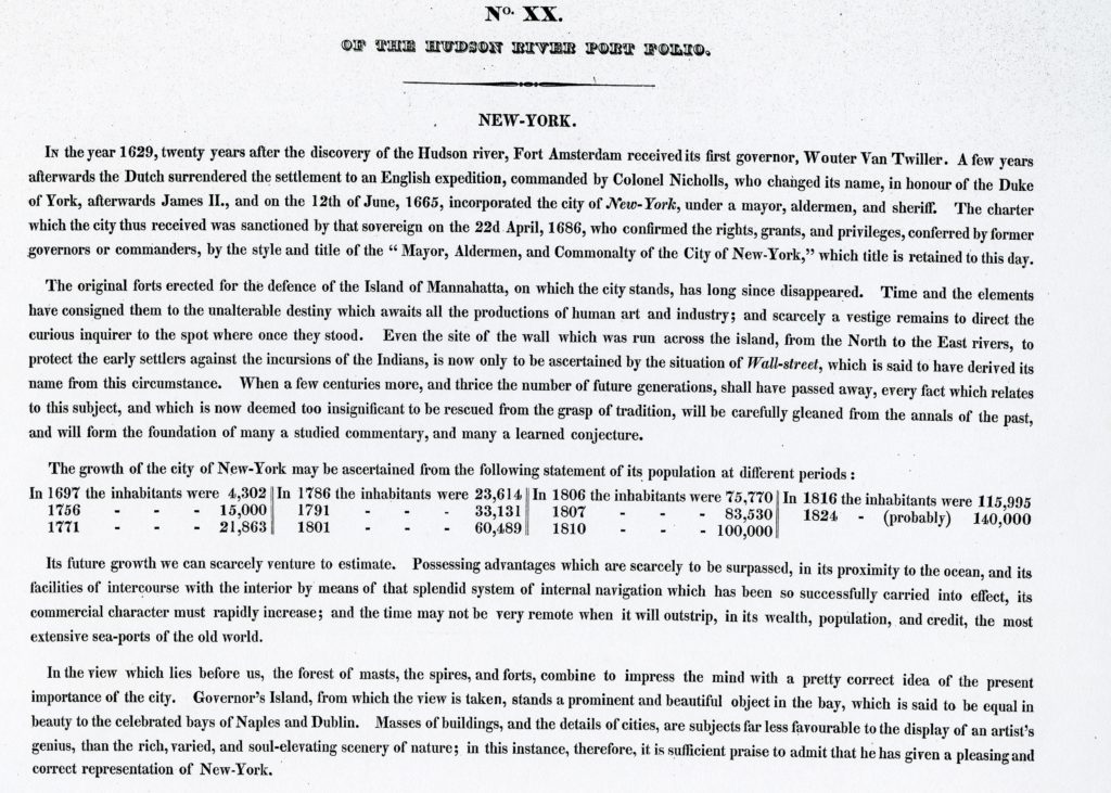
Hudson River Portfolio. New-York. William Guy Wall. Hand-colored aquatint by John Hill. Published by Henry Megary. 1821-1825. Text by John Agg (below)
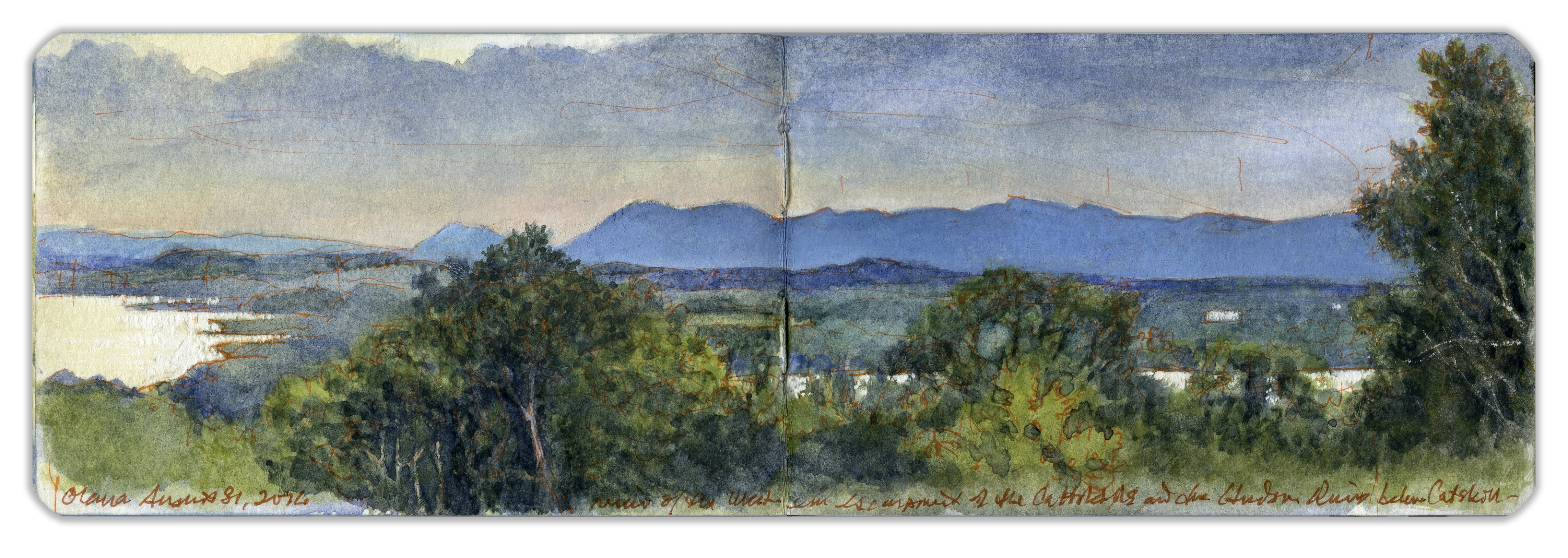
22. WESTERN ESCARPMENT OF THE CATSKILLS FROM OLANA
IN 1880, Frederic Edwin Church wrote in a letter to Henry Wadsworth Longfellow,
“Nature has been very lavish here in the gift of her beauty- I am sure you would enjoy the noble scenes which our windows command”
Sitting on the edge of the south porch at Olana—the home of Frederic Edwin Church. The day is warm, threatening rain. Wednesday. We had just driven up from the city to deliver Kathie to a meeting. The previous week we had been in London, Kew and Greenwich. Like the Royal Observatory, Olana crowns a hill that spills steeply down a wide, grassy slope. The difference here is that I am not looking across the river at the Isle of Dogs, with the new Docklands rising up behind it to the north. Dark clouds to the west seem to promise approaching thunder and rain. Visitors on a guided tour of the house peer over my shoulder. No one pauses to give me advice, or ask me what I’m doing. Just part of the scenery. A young couple walks to the edge of the hilltop. They take a selfie. A drop of rain lands on the back of my hand.
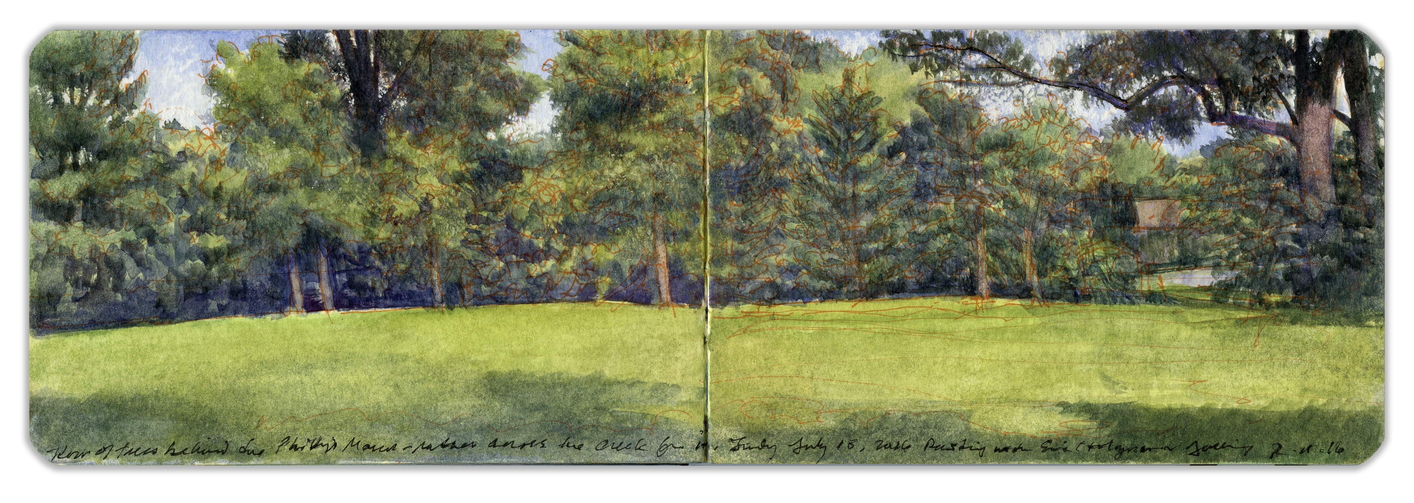
23. A FIELD NEAR PHILIPSE MILL, SLEEPY HOLLOW.
Through the village of Sleepy Hollow, just north of Tarrytown flows the Pocantico River—a tributary of the Hudson that was harnessed for hydropower by a grist-mill fed by a large pond, bordered on the west by a long, timber-built dam undergirding a narrow bridge with a wooden deck. Legend, or more correctly, the imagination of Washington Irving recalled how a Yankee schoolmaster was pursued across this bridge and driven out of town by a Headless Horseman.
The mill and the land upon which it stands was part of an hereditary estate, owned by the powerful Philipse family that controlled much of Westchester County. During the Revolutionary War, they sided with the Crown. As loyalists during the conflict, there would be no place for them in the new republic.
Today a National Historic Landmark, the site is approached through a gift-shop from which bus-tours depart for Kykuit, once the estate of the late philanthropist and statesman, Nelson Aldrich Rockefeller.
On July 15, 2016, I traveled upriver with Eric Holzman, a wonderful painter and a friend for half a century. Having grown up in Yonkers, he was familiar with hamlets scattered up and down the river. Propping up four or five canvases against a stand of wetland plants along Gory Brook, Ric set up his easel. Looming above the creek on the opposite bank, writhing branches of vine-strangled trees held him enthralled. Walking through a stand of trees, I set up at the far end of a small field. We took breaks, exchanged critiques. Such days are forever.
CURATOR’S SELECTION OF WORKS BY OTHERS
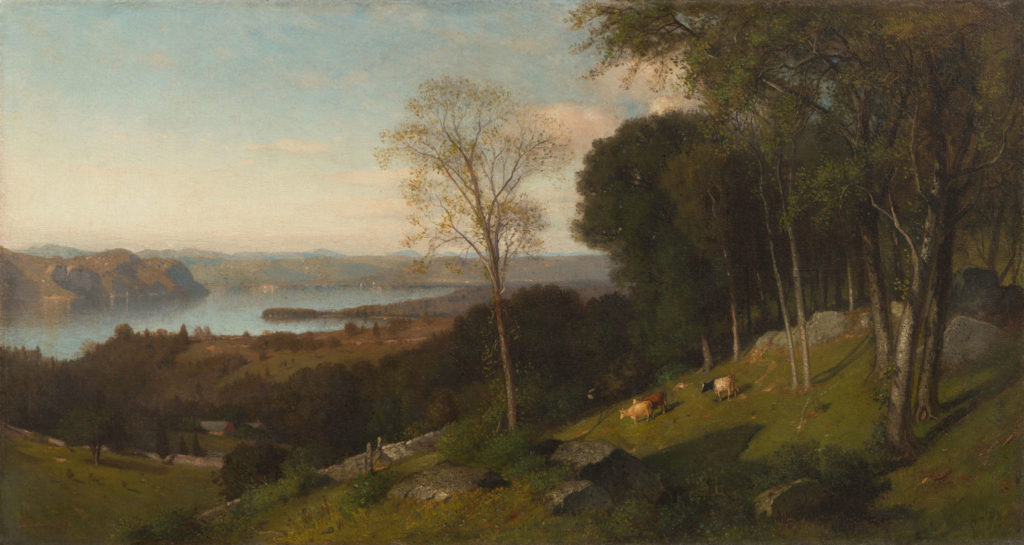
Samuel Colman.The Hudson River from Below Ossining.1867.Collection Hudson River Museum
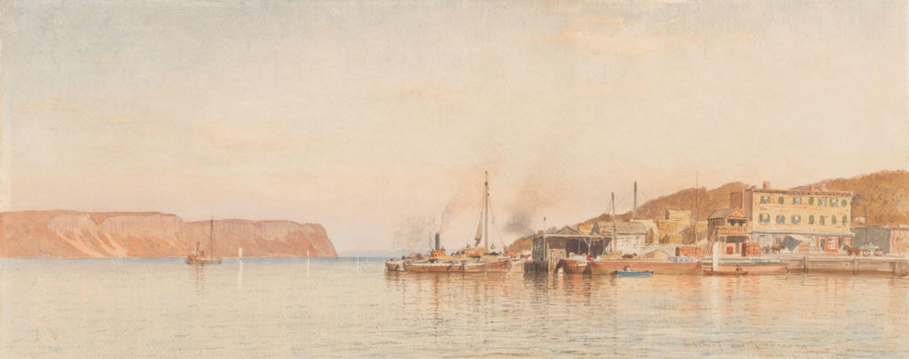
Samuel Colman. Wharf at Yonkers. 1869-70. Collection Hudson River Museum
Video: Sketchbook Animation
Video by Graham White. Digital Media Design
Link to: INSTALLATION VIEWS
Hudson River Museum. 511 Warburton Avenue. Yonkers, New York. 10701
September 13, 2019 to February 16, 2020