Richard Hovenden Kern. View of Santa Fe from Fort Marcy. 1849, Notice the emphasis given to distant landmarks.
Looking east beyond the dam lie the Ortiz Mountains, which on Dick Kern’s view of Santa Fe from Fort Marcy are identified as the Placer Mountains. Curious to compare Kern’s rendering of the vista with how it might look today, I climb up to the ruins of the fort and look southward.

View of Santa Fe. March 4, 2019. 10:52 AM. Photo by the author. Notice how minuscule are the topographical elements which in Kern’s drawing are so prominent.
Confirming that I was in the right location was the presence on the right of Bishop’s Lodge Road, known in 1849 as the Old Road to Taos. The rugged cross on the left of Kern’s drawing honors the twenty-one Franciscans killed during the Pueblo Revolt of 1680. What strikes me about Kern’s drawing are liberties he took in representing various landmarks in scale. The Sandias are instantly identifiable, as is Cerro Tetilla (nipple hill), and east-facing slopes of the Jemez Mountains to the right.

View of Santa Fe. Newspaper engraving. 1879.
A later view of Santa Fe from Fort Marcy is clearly done from a photograph. All the topographical features so visible in Kern’s 1848 rendering have been reduced to a silhouette along the horizon. The broad, open foreground in this engraving is a fiction. The town in fact comes right up to the foot of the bluff. Contemporary realist painters today might praise the verisimilitude of the later view, condemning Kern’s inaccuracies as primitive. They would be missing the point entirely. Apart from being a trained draftsman, Kern was an accomplished topographer who with his brother Ned produced maps for the official reports of the expeditions that employed them. Kern’s view from Fort Marcy blends a picturesque vista with a bird’s eye view of the town in relation to distant landmarks, to help orient the reader.

Bird’s eye view of Santa Fe, looking east. 1882 During the late 19th century these chorographic hybrids were very popular– forerunners of the tear-off map-pads available in so many tourist-information centers around the world. The designer-draftsman of this pictorial map probably never visited Santa Fe. Certain features are prominent, while others are missing. the ruins of Fort Marcy are locted on the hills to the left, just beyond the Old Taos Road.
Bohemian purists might dismiss Kern’s drawing as mere illustration, but as we have seen in the works of serious artists like Church and Bierstadt, the same tactics are used in the production of fine art. Both artists careers spanned the years during which photography became art, holding firmly to the belief that for something to be art, it must improve upon fact—even if that meant playing fast-and-loose with data. The later view of Santa Fe is nothing more than a manual-mechanical reiteration of a photomechanical factoid. Demonstrating perhaps technical skill and optical accuracy, one can learn nothing from it. Bereft of curiosity, intelligence or purpose, it is the product of mindless mimesis; the work of a copyist, not an artist.
Kern’s drawing was dedicated to identifying specific features of terrain beyond the range of optical experience. This same kind of visual jujitsu occurs in Frederic Church’s Cayambe, in which the snowy volcano is portrayed at many times its actual size. Church had done this for visual effect, Kern for calling attention to data.

Frederic Edwin Church. Cayambe. 1858. Boston Museum of Fine Arts. (Reproduced under fair use, etc.)

November 27, 2014. Thanksgiving Day. Cayambe seen from the high road between Zuleta and San Pable del Lago.
On a trip to Ecuador I tried to determine Church’s point of view, but found the peak of Cayambe shrouded in clouds. Comparing my sketch to Church’s painting gave me insight into how he might have assembled his composites. Looking back toward Imbabura from Otavallo, Cayambe would have been nothing more than a white speck on the horizon. By bringing it forward, Church lets us experience in the same moment landmarks that in fact are quite distant from one another. Moving us through time, Church takes us on a tour of northern Ecuador in a single vista. This is not plein-air painting. Nor is it realism.

Albert Bierstadt. A Storm in the Rockies. Mount Rosalie. 1866. Brooklyn Museum.
Albert Bierstadt pulls a similar trick in his 1866 painting Storm in the Rockies. Mount Rosalie (Mount Evans), now in the collection of the Brooklyn Museum. In his painting, the factual summit of the mountain is buried in clouds, into which Bierstadt punches a porthole through which we behold a preposterous snowy peak. The painting is based on sketches he produced in 1863 while traveling with author and explorer Fitz Hugh Ludlow, whose wife had become Bierstadt’s mistress. That is another story. I have been to the summit of Mount Evans on several occasions. The ascent requires a hair-raising drive along the edge of a precipice, dodging wild sheep and daredevil cyclists.

Wild Sheep at summit Lake parking area (above) June 18, 2016
Summit of Mount Evans (below) June 18, 2016

The actual summit of Mount Evans-Rosalie is on the left-hand side of this composite photograph. The Chicago lakes are visible to the right. Just below the summit one can walk to the edge of an alpine lake that drains into a declivity on the north face of the mountain, into an escalade of small lakes. Bierstadt’s point of view was near the lowest of these, (31.6191 x 105.6313) near where its outflow forms Chicago Creek. Its waters descend through Idaho Springs, feeding into Clear Creek, which passes Golden en route to its confluence with the South Platte river just north of Denver.

Map of New Mexico Territory. Richard H. Kern. 1851. Collection Huntington Library. San Marino, CA
Below White Rock Canyon the Rio Grande flows below table-lands to the east and a series of cañadas to the west—deep ravines clawed into the southeastern slopes of the Jemez volcano, as if by a giant hand. Through these defiles seasonal creeks dump rainwater and snowmelt into the river. One of these—Rito de los Frijoles descends through Bandelier National Monument. Named for noted archaeologist, ethnologist and preservationist Adolf Bandelier (1840-1914), the National Park Service interprets more than thirty thousand acres ranging in elevation from five to ten thousand feet. Visible evidence of human habitation spanning thousands of years included Tyounyi ruins and other excavated pueblos, along with modern reconstructions, original cliff-dwellings and petroglyphs.

White Rock Canyon
Winding beneath high bluffs, the river widens gradually. Its flow rate decreases as the current enters the upper reaches of Cochiti Lake. An impoundment of nearly forty million gallons on average, this body of water is created by a large dam built by the Army Corps of Engineers between 1965 and 1973. One would presume that in such a dry country the function of the dam would be water-collection for irrigation. Prior to its construction, the combination of heavy snowmelt and a narrow channel would transform the Rio Grande into a raging torrent. Flooding bottomlands dedicated to agriculture, the damage wrought immense hardship on indigenous communities downriver, such as Cochiti and Santo Domingo pueblo, and Spanish settlements Peña Blanca and Algodones. These, and other farming settlements up and down the river depended on a system of acequias, water-bearing ditches shared by the community. New Mexicans are by nature friendly and easy-going. In picking a fight, defaming a mother’s virtue always works. In New Mexico, a disagreement over water-rights will get you there quicker.

Topo map of Cochiti Dam and Lake.
I first visited Cochiti in 1980. The lake was seven years old. Unlike today, the reservation was open to public use. Unpaved roads led north to the ash-fields and cañadas below Valles Caldera, or west to the tent-rocks at Kasha-Katuwe, Keresan for white rocks. In 2001 the area was designated a National Monument. Santa Fe County and Albuquerque have over the past thirty years both doubled in population, leading the Cochiti Pueblo community to close its lands to unauthorized visitors. At the same time, one is greeted today by a modern welcome center, café and gift-shop. One of the few areas open to the public is Cochiti Dam.
Driving toward the hamlet of Cochiti Lake I turn right, passing a cluster of tribal utility buildings. Veering right again, I descend a long incline that terminated at a wide-boat-landing with a short dock to its left. A local man stood in the water, wrestling his boat onto a trailer. To either side of the ramp are short stretches of beach. Parking in the lot to the right, I carried my gear across the boat-ramp, sitting down at one of the concrete picnic-tables behind the beach. I am the only non-indigenous person at the site. A young couple sits at the next table, staring into their cellphones. A fisherman walks by, looks at me and nods. Before long my work absorbs me, not so much that I would be grateful for the absence of curious onlookers. One expects diffidence from Native Americans toward Anglos visiting Indian land. History has given them no reason to trust our kind. I am mindful also that the lake and its shores are under the control of the Army Corps of Engineers, which adds yet another nervous level to the human layer-cake one finds in The Land of Enchantment.

Cochiti Reservoir. March 6, 2019. Southeast from 35.6361204 x 106.3222467
Gazing across the water, the Ortiz-Placer range is minuscule, barely visible. Taking a page out of the Kern-Church playbook, I enlarge the distant mountains in relation to the lake and dam. An hour before dusk, shadows crawl down the hillside and march across the lake. Rosy light wash the faraway peaks. Consumed with my task, I fail to notice that everyone had left. A police SUV idles in the parking-lot. Better to leave without waiting to be asked.
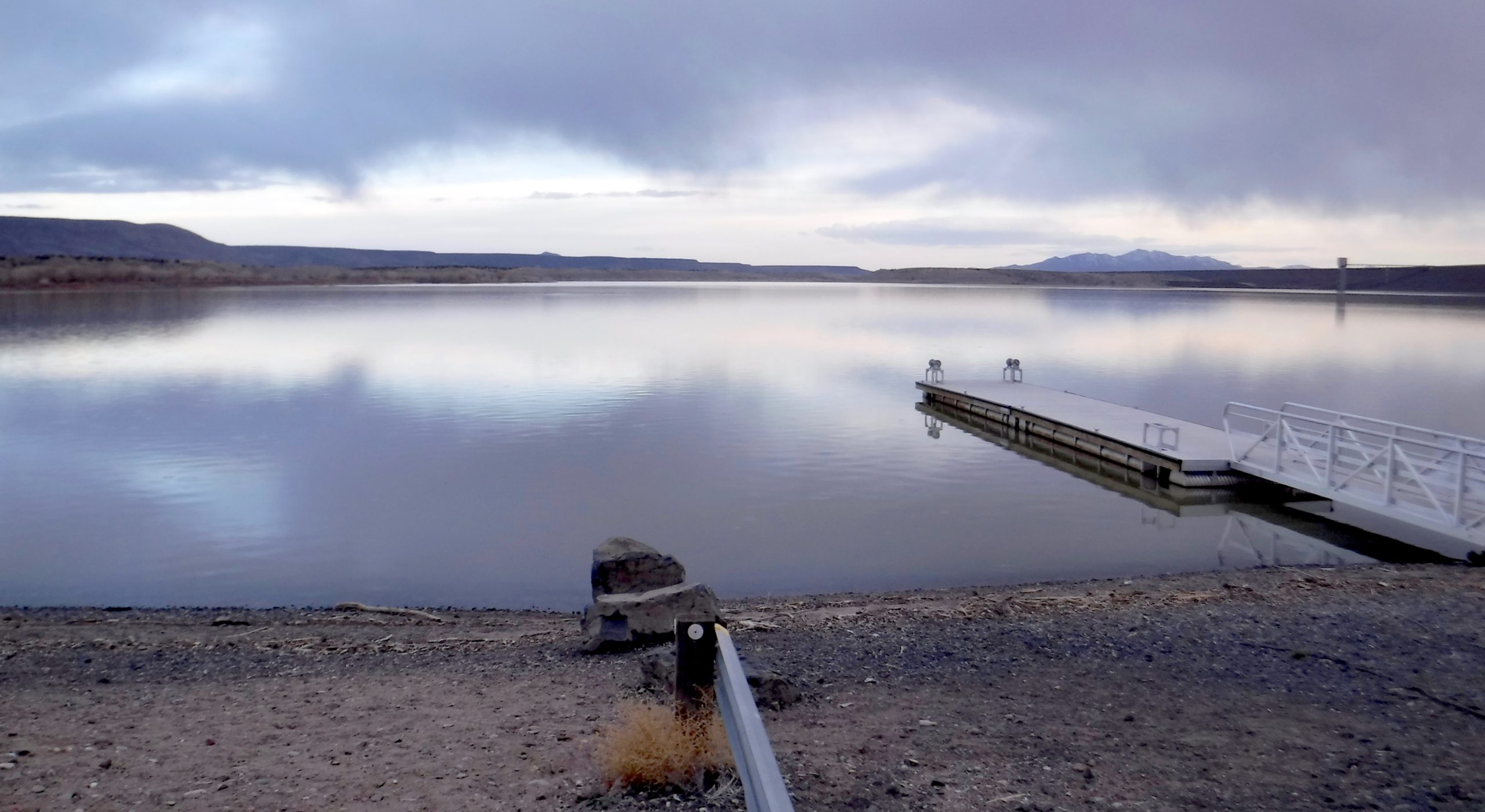
March 6, 2019. Looking Southeast across Cochiti Lake. Photograph by the author.
Follow James Lancel McElhinney and The Sketchbook Traveler on Facebook, Linkedin, Twitter and Instagram.
Peruse previous posts here. Dispatches #1-70. April 1-June 8, 2020.
Coming Soon: Hardcover. $24.95. From Schiffer Publishing. Release date: September 2020.