Category Archives: Dispatches

April 11, 2020. Saturday. Q.T. Dispatch #11

Summit SpSummit Springs Battleground. Sterling, Colorado. Oil n canvas. 50 x 66 inches. 2000

Journal additions January 2, 2000 Summit Springs, Sterling Colorado
Stopping at a Texaco station in Fort Morgan for fuel, the grease-monkey manning the pump warned me that Wray—and nearby Beecher’s Island battlefield—would be another 90 miles, more than two hours’ drive to the east, serious distances that in the dead of winter would demand a more serious vehicle than my fishtailing rear-wheel drive 1996 Ford Ranger.
I never traveled into the Rockies or out onto the plains, without an emergency supply of energy bars and water, a couple of Mylar survival blankets, an army surplus folding spade, some flares, and a .357 revolver loaded alternately with snake-shot and hollow-points. My first cell-phone purchase was almost a year in the future. GPS was unavailable for civilian use. The gas-station attendant warned me to be on the lookout for police.
“It’s a hell of a boring trip along here. Cops out there are plenty bored. They might just stop you to have someone to talk to. I got pulled over, once driving a truck that couldn’t go 60. Speed limit out here is 65.”
He tells me that brother got stopped for speeding one day on the road to Wray. An open warrant on some minor offense landed him in the county calaboose. Getting to Beecher’s Island would require a full day of cop-dodging mind-numbing travel in a four-wheel drive vehicle. That was the gist of it. This new intelligence caused me to abandon the idea in favor of a return visit to Tall Bull’s last stand.
Steering onto the off-ramp at Sterling I turned east, diving into the rolling high plains that spread out before me like a vast sea of burnt grass. Wire fences snagged tumbleweeds. A jackrabbit darted across the unpaved road fifty yards ahead. Clouds of brown dust tossed up in the whirlwind wake of my pickup truck. Beneath golden skies, the blue saw-tooth horizon of the Rockies disappeared from my rearview
Arriving at Summit Springs battlefield at around 3:30 in the afternoon, a bright sun blazed above a wall of dark clouds rolling in from the southwest. Stepping out of the vehicle, I noticed a few clumps of brown fur on a patch of earth stained with about as much blood as might be contained by a rabbit. Strewn about were more bits of the same fur, souvenirs of a savage feast enjoyed perhaps by some coyote, or feathery raptor.
Making drawings and photographs of the deep gully canyon and the narrow vale that separated me from it, I worked in haste as storm-clouds approached
Someone had put the leg bone of a slightly larger animal, perhaps a coyote, atop Susanna Alderdice’s grave-marker. A new penny rested on a ledge of a stone monument to Frank and Luther North. The stone obelisk had been dedicated on the fortieth anniversary of the fight in 1909. Luther North attended the ceremony. His more famous brother Frank had passed away many years before. A member of Buffalo Bill Cody’s Congress of Rough Riders, Frank North later struggled with celebrity, drink and depression.
The North brothers had earned a reputation by leading a battalion of Pawnee scouts into various actions against hostiles during the 1860s and 1870s. Attached to Eugene Carr’s command, the North brothers and their Pawnee Battalion participated in the attack against Cheyenne Dog Soldiers, who were encamped along a small creek near a maze of deep gullies visible today.
Re-enacted many times his “Wild West” show, the battle culminates with Carr’s favorite scout rushing to the aid of two white women. Moments after Susanna Alderdice is tomahawked, Buffalo Bill Cody comes galloping up. He dispatches Tall Bull with a six-shooter, saving Teutonic beauty Maria Weichel from the same fate as her fellow captive.
An eyewitness account alleged that amid the confusion and panic during Carr’s attack, Weichel and Alderdice were confronted by Tall Bull’s wife, a jealous woman who sought to kill them both. Alderdice took the first bullet and died instantly. Struggling with her assailant, the rifle discharged, sending a bullet through one of her breasts just as Cody, or perhaps someone else, intervened to save her. Described as unusually attractive, a disfigured bosom did not keep Weichel from finding a husband and getting on with her life. Conflicting reports credit Frank North with killing the Cheyenne leader, who with his men had taken shelter in the muddy canyon northwest of the monuments. Most are willing to let Cody take the credit. Scholars and western-history buffs debate the point, but Carleton Young’s memorable line from John Ford’s classic film, The Man Who Shot Liberty Valance, seems to sum it up.
“When the legend become fact, print the legend”

Unlike Cody, the North brothers today have faded from memory. One of the most touching battle markers I have ever visited is a standing vertical slab of rough-cut stone, honoring the Cheyenne boy who was shot down, as he attempted to rescue the pony-herd. Bundles of dried flowers and herbs rest around its base. Smooth pebbles balanced on its flat upper edge remind me of visiting-stones on Jewish graves, or Major Patrick Ferguson’ grave.
On October 7, 1780, a force of Patriot militia attacked a detachment of British and Loyalist troops under the command of Ferguson at Kings, Mountain North Carolina. Killed in action, hastily buried by his slayers, Ferguson’s body was covered with stones. Adding stones to the pile, reverent visitor over the years have built a substantial cairn. The tradition seems to traverse cultural boundaries. One of the landmarks of Ireland is Cnoc na Riabh, the grave of Queen Maeve. The large cairn crowns a ribbed hill, on the Atlantic coast of Sligo. Leaving a stone may bring good luck, but removing one risks being cursed. No archaeologist has dared to excavate the monument.
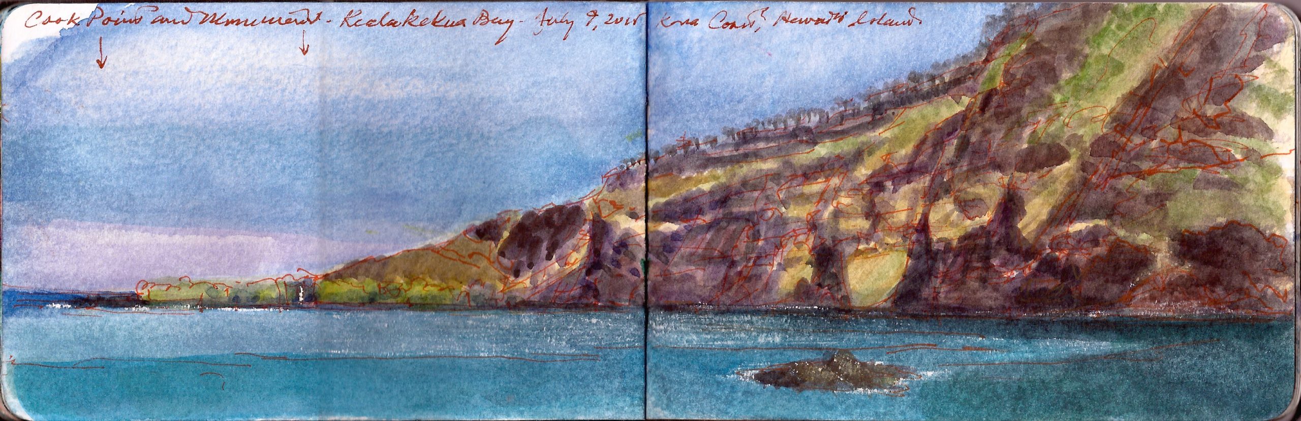

Kealakekua Bay. Hawai’i Skechbook. July 9, 2015. Across the bay a small monument stands, marking the place where Royal Navy Captain James Cook was killed in a skirmish that could have been avoided by giving the indigenous warriors a bucket of nails.

I encountered similar traditions on the island of Hawai’i. Leis had been presented to me as greeting-gifts and marks of respect. Discovering that they never would be allowed to return with me to the mainland, I drove to the end of Puuhonau Road, to cast them into Kealakekua Bay. Standing near a small heiau, two indigenous men were pitching unlicensed snorkel-tours. The younger man had a stunning physique, his torso covered with traditional tattoos. Explaining my dilemma to them, the young man said to me,
“These leis were made with love, and given to you with respect. They’re yours. It’s a bummer you can’t take them home with you. I appreciate that you don’t want to put them in the garbage. Go ahead and lay them on the water. That’s cool. But whatever you do, don’t take anything from the island, not even a shell, a rock or a pebble. They belong to the sea and the land. We have to respect that.”
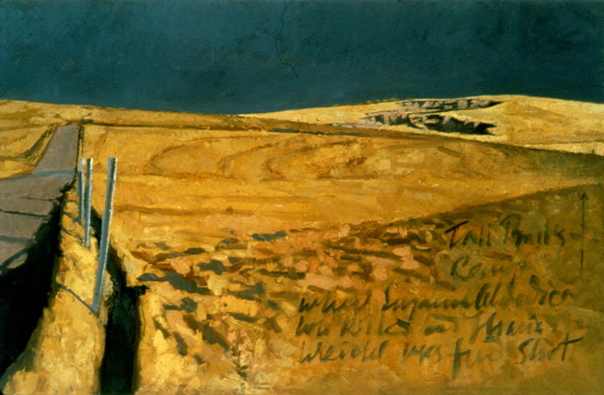

Summit Springs Battleground. Sterling, Colorado. Oil on canvas. 30 x 5 inches. 2000

Setting up next to the battle-monument, I take notes and make sketches. A large SUV arrives. Three white males emerge, dressed in blaze-orange ball-caps and vests. Drawing their weapons from soft cases, they nod to me politely, scramble over the wire-fence and march off to a pond half a mile away. Working on a small oil-study, I hear the distant bark of shotguns. An hour later the hunters return, each with a couple of canvasback ducks. The depart. I linger awhile. After five o’clock the light fades. The mercury suddenly plunges. Purple shadows flood the wide hollows between prairie-swales tipped with gold. A sudden burst of sunlight reveals Tall Bull’s last refuge, jagged gashes, ripped by giant claws into the prairie. Removing the painting from the easel, I set the panel inside the upturned lid of a cardboard banker-box that served as my drying-tray. Wiping my brushes, I scraped the palette, packed my box-easel, securing it all with bungee cords, in the bed of my truck. Climbing into the cab, I take a swig of cold coffee, light a cigar and throw the truck into gear. Loading the Chieftains’ album, The Long Black Veil into the cassette-player, the first track is a lamentation performed by Sting.

Sé mo laoch mo ghile mear
Sé mo Shéasar, gile mear
Suan gan séan ní bhfuair mé féin
Ó chuaigh I gcéin mo ghile mear

A bold and gallant chevalier
A high-born scion of gentle mein
A fiery blade engaged to lead
He’ll break the bravest in the field

Driving up and away from the muddy turnaround is like rising up out of a tomb. In raking sunlight, dust-clouds chase my truck, glowing like afterburners. Stretching out across the plain from both sides of the road, blazing amber stubble fades to rust. A jackrabbit darts across the road. Storm-clouds roll east toward Kansas to bust up trailer-parks, or deliver farm-girls to Munchkins. Along the southwestern horizon, the twin summits of Long’s Peak rise above the shadowed plain. A gash in the clouds glows fiery orange. A thousand points of light appear in black skies overhead. Near the ground an eerie toxic glow to the southwest–the orange luminiescence of a great metropolis. Night falls over central Colorado.
Southbound from Fort Morgan, on Interstate 76, traffic increases. Occasional truck-stops, mini-marts and ranches give way to housing-clusters, settlements, and the sprawling fringe of suburbia. Returning to Denver at night was like flying into the bright heart of a galaxy. Abandoning the darkness and desolation of the High Plains, an unsettling sense of absence overtakes me. Something forgotten, or left behind. Nobody lives at Summit Springs, but something abides.

(A preview of SKETCHBOOK TRAVELER by James L. McElhinney (c) 2020. Schiffer Publishing).
Copyright James Lancel McElhinney (c) 2020 Texts and images may be reproduced (with proper citation) by permission of the author. To enquire, send a request to

ed******@ne***********.com


April 10, 2020. Good Friday. Quaranteam Traveler. Dispatch #10

This is then tenth in a series of quotidian website blog-posts, of writings and artworks that celebrate personal mobility, in pursuit of mindful engagements with history, nature and the environment. In relation to a finished painting, or an essay, this process is no less a work of art than is the tree to the fruit it bears. In a sense, this practice may be ceremonial, acts of reverence, in beholding the world around us. Offered as messages of hope and solidarity, these posts will appear every day, until these dark days are behind us.

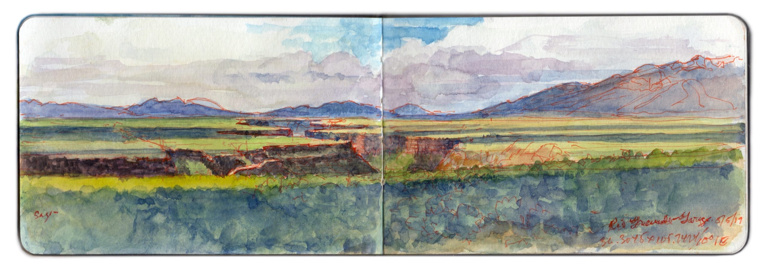
Roadside vista. Rio Grande Gorge from NM68. 10.0000 degrees NE. from 36.4105 x 105.2424. May 5, 2019.
Two hikers climb over the wire fence hundred behind me (south). Motorists pull over and snap photos. Almost every one of them hold their phone or camera, arms fully extended above their heads, as if they could peer into the nearly thousand-foot ditch two miles away. Speeding past, drivers honk and wave at me. Taos Valley is actually the southernmost extremity of the San Luis basin, the northern end of the Rio Grande Rift. The two distant peaks are volcanic domes. Ute Mountain lies dead ahead, with Antonio Peak to the left. Alluvial sediment, laid down over volcanic ash and lava flows, is crossed by the river through a deep gorge. While the waters are navigable, they tend to be treacherous at this time of year. Record snowpack this past winter promise dramatic floodwaters later this spring. The plain is covered in Desert Sage (Salvi dorrii) and Pinyon Pine (Pinus monophylla). Taos Pueblo is at the foot of the mountains to the far right. Across the river, County Road C-8-115 descends to Taos Junction Bridge, just below the confluence of Rio Pueblo de Taos. The road continues south through Orilla Verde and Pilar, terminating at NM68

(A preview of SKETCHBOOK TRAVELER by James L. McElhinney (c) 2020. Schiffer Publishing).

Copyright James Lancel McElhinney (c) 2020 Texts and images may be reproduced (with proper citation) by permission of the author. To enquire, send a request to

ed******@ne***********.com


April 9, 2020. Q.T. Dispatch #9

Through the direst days of this crisis, we think of our friends and loved-ones, who also shelter in place. These are messages of hope, not just for our own survival, but the hope that when storm-flags are lowered, we might rediscover things we took for granted, drawing strength, wisdom and compassion from deeper engagements with nature.

Last week I published the first in a series of daily website blog-posts, of writings and artworks celebrating personal mobility, in pursuit of mindful engagements with history, nature and the environment. In relation to a finished painting, or an essay, this process is no less a work of art than is the tree to the fruit it bears. In a sense, this practice may be ceremonial, acts of reverence, in beholding the world around us. Offered as reaffirmations of hope and solidarity, these posts will appear every day, until these dark days are behind us.


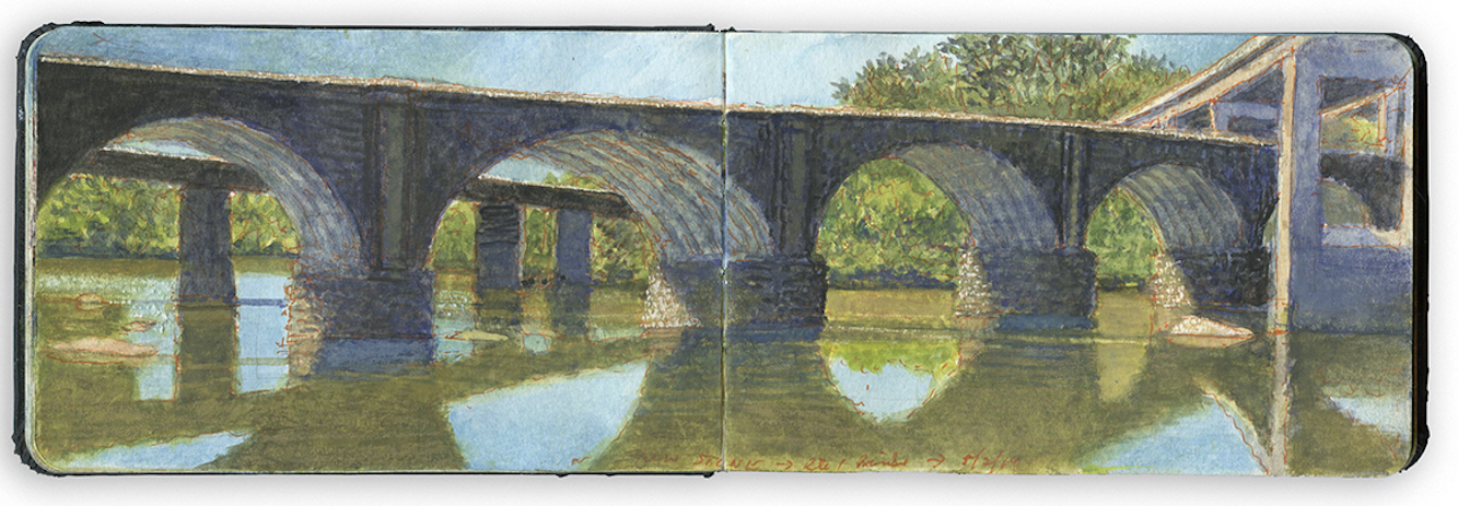
Twin Bridges Below Roosevelt Boulevard On-ramp, Philadelphia. May 2, 2018.

Exploring the banks of the Schuylkill River in 2018, between the mouth of Wissahickon Creek and Fairmount Water-Works, I filled a sketchbook with journal-paintings. Later that year these would become a limited-edition suite of prints, and the centerpiece of the installation O.T.W. On the River, at Independence Seaport Museum in Philadelphia.

Twin Bridges at East Falls marks the western boundary of Philadelphia’s Fairmount Park. Popularly known as Twin Stone, they mark the western extremity of most barge-club rowing. Submerged rocks bid a cool welcome, yet dauntless oarsmen and women will venture upstream as far as Flat Rock near the vertiginous neighborhood of Manayunk.
Nearest the viewer, the Philadelphia & Reading Railroad Schuylkill River Viaduct, constructed of stone ribbed-skew-arch construction, the span was regarded as an engineering marvel when it was completed in 1856. Designed by engineer Gustavus Nicolls, its six arches were first modeled in soap. The bridge was constructed under the direction of master stonemason Christian Schwartz, who paid his workmen in coin and whiskey. The bridge beyond was added in 1890, creating a Y junction, merging the tracks on the east side of the river. A large masonry barrel-vault crosses Kelly Drive at its eastern head. The concrete span towering above them to the right is the northbound connecting ramp that links Interstate 76 to U.S. Route 1.
Efforts to restore the river have made great progress. One fouled with coal-silt and effluvia from sewage and industry
While painting this scene, I watched two brothers land a fifty-pound flathead. A passing restauranteur bought the catfish on the spot. Witnessing the transaction, a trio of snapping-turtles tread water offshore, in a patch of bright sunlight

(A preview of SKETCHBOOK TRAVELER by James L. McElhinney (c) 2020. Schiffer Publishing).

Copyright James Lancel McElhinney (c) 2020 Texts and images may be reproduced (with proper citation) by permission of the author. To enquire, send a request to

ed******@ne***********.com


April 8, 2020. Q.T. Dispatch #8

Here in New York City, the darkest days of the pandemic may soon be over. Elsewhere others brace themselves for the fury of its onslaught. Many thanks to you who shelter in place. Shame on those who do not

One week ago I published the first in a series of daily blog-posts, of writings and artworks that celebrate personal mobility, in pursuit of mindful engagements with history, nature and the environment. In relation to a finished painting, or an essay, this process is no less a work of art than is the tree to the fruit it bears. In a sense, this practice may be ceremonial, acts of reverence, in beholding the world around us. Offered as messages of hope and solidarity, these quotidian posts will appear every day, until these dark days are behind us.


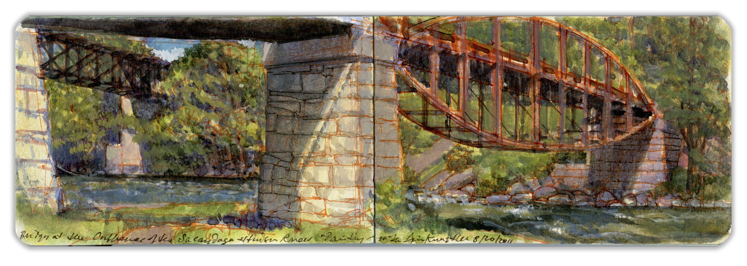
Twin Bridges at the Mouth of the Sacandaga River, Hadley New York.

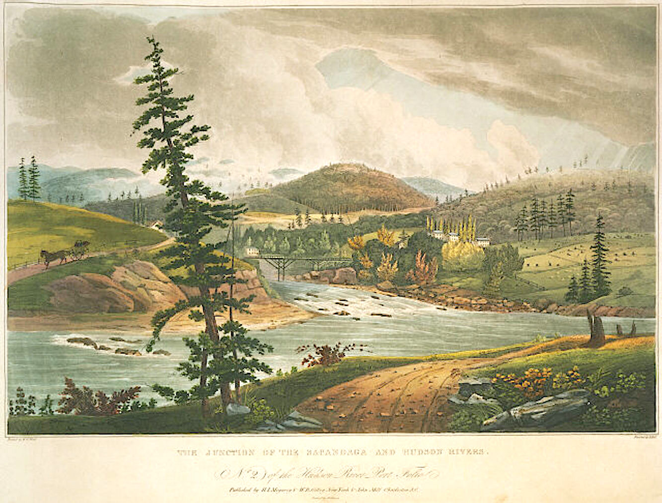
Traveling down the Hudson in 1820 with Irish landscape painter William Guy Wall, travel-writer John Agg describes the land around the mouth of the Sacandaga as,

“…broken and precipitous; and the natural course of the current is impeded and distracted by large fragments of stone, which choke up the narrow channel. The character of the scenery is wild, ferocious and solitary sublimity; lofty and irregular acclivities, covered the gloomy verdure of interminable forests and glens; over whose terrific depths unchanging darkness lowers.”

On a visit to old friend and noted author James Howard Kunstler, we head out to paint au plein-air. Below Hadley, we park alongside the Old Corinth Road, then descend a steep embankment. Setting up on a grassy rise, along the banks of the Sacandaga, to our left we find two historic bridges. The oldest is a parabolic-lenticular bow-truss bridge, resting on stone piers. Built in 1885 to replace the earlier bridge Agg and Wall had beheld, sixty-five years before, by 1994 it had fallen into disrepair. Deemed unsafe, the bridge closed to traffic in 1994. Five years later, Saratoga County considered replacing the bridge. Preservationists raised funds to restore the bridge, which reopened to traffic in 2005. Beyond it we see a steel deck-truss railroad-bridge, also built on stone piers in 1943. The day was hot. Mosquitoes vexed us without mercy. Jim waves at a fisherman wading in the stream.
Departing at end of the day, we cross the Hudson. Looking back toward our motif from the prospect Wall had taken, The rocky stream is as it had been, two hundred years before. Much had changed. Pastures and meadows have disappeared. Spreading over the land a new forest stands, as far as the eye can see. Wild-space has reclaimed its own, save for two relics of human desire, in the geometry of these twin bridges.


William Guy Wall. The Junction of the Hudson and Sapandaga Rivers. No. 2 of the Hudson River Port-Folio. 1821. Collection of Metropolitan Museum of Art, New York. Reproduced under fair use, etc.
Note: Standard spelling of indigenous names did not exist when Wall and Agg visited the Hadley-Luzerne area in 1820. Names were spelled phonetically, according to the whim of the writer. Sapandaga today is spelled Sacandaga.

(A preview of SKETCHBOOK TRAVELER by James L. McElhinney (c) 2020. Schiffer Publishing).

Copyright James Lancel McElhinney (c) 2020 Texts and images may be reproduced (with proper citation) by permission of the author. To enquire, send a request to

ed******@ne***********.com


April 7, 2020. Q.T. Dispatch #7

Battling the COVID-19 pandemic, we all patiently wait for the crisis to pass, including many dear friends everywhere who are sheltering in place. Almost a week ago I published the first in a series of daily website blog-posts, of writings and artworks that celebrate personal mobility, in pursuit of mindful engagements with history, nature and the environment. In relation to a finished painting, or an essay, this process is no less a work of art than is the tree to the fruit it bears. In a sense, this practice may be ceremonial, acts of reverence, in beholding the world around us. Offered as messages of hope and solidarity, these posts will appear every day, until these dark days are behind us.


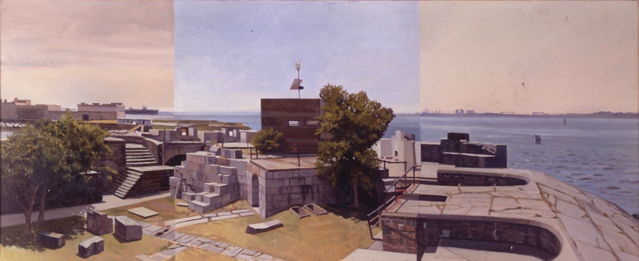
Fort Wool, Hampton Roads, Virginia. Completed July 20, 1992. Oil on canvas. 22 x 50 inches. Private collection

In February 1991, I moved from Philadelphia to Richmond Virginia. For the next three years, I researched, explored, and painted Civil War sites, which I saw as physical memories of past conflicts, and thus symbolic of how the American landscape is a shaped by an ongoing quarrel about what it is. The following is drawn from my journals.

July 10, 1992. Fort Wool. Rip-Raps Island. Hampton, Virginia. 4 pm.
My headache returns, now worse than before. Because the painting is going so well. I soldier on. Watching all the pieces fall into place, something tells me that I might be pushing myself too hard. Feeling slightly disoriented. I dump water over my wrists and head. What remains in the bottle soaks a handkerchief, which I fold up and place on my head, under my straw Amish hat.
The heat has become nearly unbearable. Landing twenty yards away, a gull jumps up with a squawk, taking flight. So hot was the concrete. Through the din of harbor-traffic, motorboat engines, bridge-traffic, public-address announcements drifting across the water from Fortress Monroe, I hear something else. Unable at first to identify the sound, I hear the haunting wail of bagpipes.
Am I losing my mind? Should I call down for help?
In my attempt to dismiss the hallucination, I envelope myself in silence through sheer force of will. The music only grows louder. Chills run down my spine. Sweat stings my eyes. Just then I hear something else–low and steady, splashing and rumbling.
Looking to my right two hundred yards off, a grey form slices the waves. Standing at attention, dressed in their whites, crewmen line the port rail. Alone on the bridge stand a sailor. Straight as a ramrod, hands in front, his fingertips work on the chanter. The bladder is tucked up under his arm. Drones bristle above his left shoulder. Playing a tune we all know so well, it nearly lays me flat. John Newton’s hymn of shame and salvation, Amazing Grace pierces the air. Seabirds glide on warm breezes. A warship slips past us, on its way home.

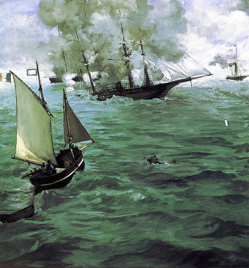
Postscript: My painting of Fort Wool in 1998 was included in the exhibition Sacred Sites, curated by Brooks Johnson at the Chrysler Museum in Norfolk, Virginia, where it hung alongside Edouard Manet’s 1864 painting, The Battle of the Kearsarge and Alabama, in the collection of the Philadelphia Museum of Art. Growing up in the Delaware valley, I often visited the museum. Manet’s painting was always one of my favorites.

The Battle of the Kearsarge and Alabama. 1864. Collection Philadelphia Museum of Art

(A preview of SKETCHBOOK TRAVELER by James L. McElhinney (c) 2020. Schiffer Publishing).

Copyright James Lancel McElhinney (c) 2020 Texts and images may be reproduced (with proper citation) by permission of the author. To enquire, send a request to

ed******@ne***********.com


April 6, 2020. Q.T. Dispatch # 6

In 2019, I made four trips to Santa Fe. Exploring the Rio Grande between John Dunn Bridge at the confluence of Arroyo Hondo, and Cochiti Reservoir to the south, key sites were celebrated in journal-painting. Today’s post is dedicated to dear friends and loved-ones weathering the storm in New Mexico and Colorado.

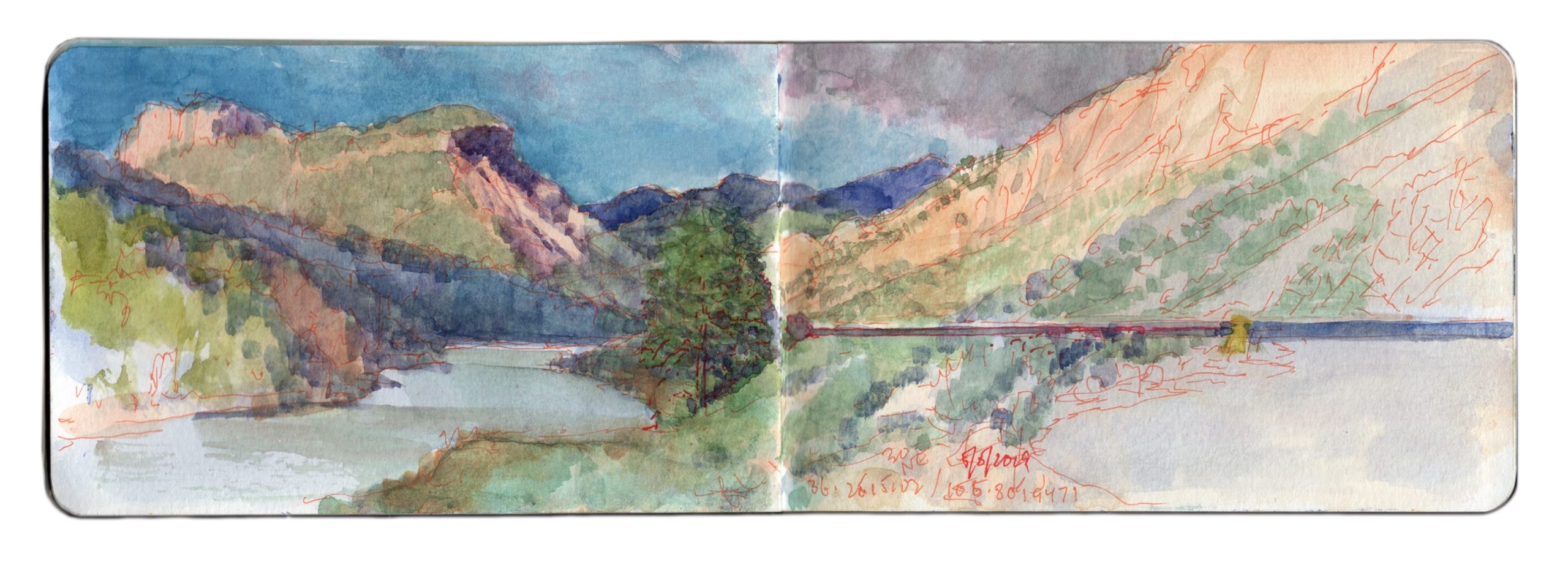
Roadside Vista. Below Pilar, Route NM68. 30 degrees NE from 36.2515102 x 105.801947. Cinco de Mayo, 2019

Driving north on NM68, through Embudo and a cluster of homes known as Rinconada, motorists are greeted by a distinctive geological formation. A Spanish settlement grew up at the base of the hill, on the site of an Apache village destroyed by Diego de Vargas during the Reconquista of 1684. Twenty-Five Spanish families in 1795 had taken possession of a Royal land-grant known as Cieneguilla, which in English might be translated as “little swamp”.
The southeastern face of the hill sheltering the village is sheer rock-face, crowned by a slight overhang. From certain angles, it bears a pareidolic resemblance to familiar images of the Virgin Mary.
Seven years after the crucifixion of Jesus, Saint James the Apostle preached the Gospel in Iberia. According to belief, the Blessed Virgin appeared to him in a vision, from which he received a pillar of Jasper, and instructions to sanctify a house of prayer in her honor. The following year, Saint James established a small church in Zaragoza. Growing over the centuries, the Basilica de la Nuestra Senora de Pilar has become one of two sites most sacred to Hispanic peoples. The other is Santiago de Compostela, which enshrines the relics of Great Saint James.
Scraping a living out of the fertile margins of the great river, Catholic Spaniards may have regarded the hill towering above them as their protectress and salvation. Pilar today is home to the Rio Grande Gorge visitor center, café, and a rafting-tour company.
Today, Taos County Road C-115 runs through the village, then upriver through Orilla Verde to Taos Junction Bridge. Clinging to the vertiginous walls of the gorge, the road climbs to the rim via a series of hair-raising switchbacks. Turning northward, it crosses the plain, intersecting US64 just west of the Rio Grande Gorge Bridge. Continuing north past Pilar on NM68, the road climbs for several miles before reaching the southern edge and wide expanse of the San Luis Basin of the Rio Grande rift

(A preview of SKETCHBOOK TRAVELER by James L. McElhinney (c) 2020. Schiffer Publishing).

Copyright James Lancel McElhinney (c) 2020 Texts and images may be reproduced (with proper citation) by permission of the author. To enquire, send a request to

ed******@ne***********.com


April 5, 2020. Q.T. DISPATCH #5

Moving deeper into the pandemic, we patiently shelter in place, waiting for the crisis to pass. Today’s post is dedicated to my valued colleagues and treasured friends, soldiering on in Philadelphia.

Last Wednesday I published the first in a series of daily website blog-posts, of writings and artworks that celebrate personal mobility in pursuit of mindful engagements with history, nature, and the environment. In relation to a finished painting or an essay, this process is no less a work of art than is the tree to the fruit it bears. In a sense, this practice may be ceremonial, acts of reverence, in beholding the world around us. Offered as messages of hope and solidarity, these quotidian posts will continue to appear, until these dark days are behind us.

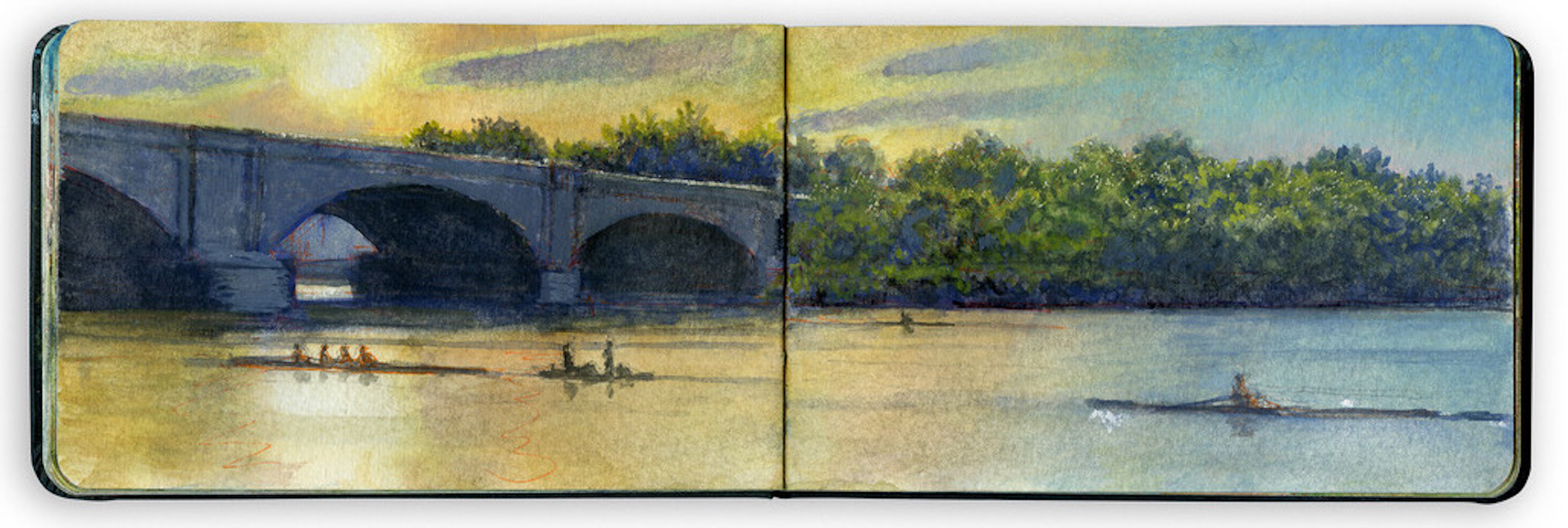
SUNSET: COLUMBIA RAILROAD BRIDGE. Schuylkill River Sketchbook. 2018

Getting out on the water before work is a Philadelphia tradition that began in the nineteenth century. Many of the first oarsmen were tradesman and clerks working a six-day week. Social diversity is an enduring trait of amateur competitive rowing. Barge club memberships today include CEOs and plumbers, men and women, young and old, as well as people of color.
On page 26 of her book Thomas Eakins: The Heroism of Modern Life, Elizabeth Johns writes:

Rowing had become an art, and Rowers potential heroes. The stroke called for by the delicately balanced boats was . . . a calculated series of movements of body and oar, based on principles of efficiency and grace. So disciplined and comprehensive a leisure did it seem . . . that rowing was a modern reinstitution of the Greek ideal of the union of mental and physical culture.

Popular rowing images celebrate sunshine, pageantry, races, and regattas. Eakin’s painting of Max Schmitt resting on his oars tells a different story, one of solitary endeavor. Measuring each stroke, the body adopts a rhythmic movement as the belly of the scull slices through the water. Riverbanks retreat into the distance, soaring bridges mark your wake. Mind, body, time, and the river, all become one, greeting the day or bidding it farewell.

(A preview of SKETCHBOOK TRAVELER by James L. McElhinney (c) 2020. Schiffer Publishing).

Copyright James Lancel McElhinney (c) 2020 Texts and images may be reproduced (with proper citation) by permission of the author. To enquire, send a request to

ed******@ne***********.com


APRIL 4, 2020. QUARANTEAM TRAVEL. DISPATCH #4

QUARANTINE RERUNS: Each day during the early days of the pandemic, I published a blogpost based on my travels. This is the fourth.

In 2019, I made four trips to Santa Fe. Exploring the Rio Grande between John Dunn Bridge at the confluence of Arroyo Hondo, and Cochiti Reservoir to the south, key sites were celebrated in journal-paintings. Today’s post is dedicated to my all dear friends and loved-ones in New Mexico and Colorado, as they weather the storm.

Last Wednesday I published the first in a series of daily website blog-posts, of writings and artworks that celebrate personal mobility, in pursuit of mindful engagements with history, nature and the environment. In relation to a finished painting, or an essay, this process is no less a work of art than is the tree to the fruit it bears. In a sense, this practice may be ceremonial, acts of reverence, in beholding the world around us. Offered as messages of hope and solidarity, these posts will appear daily, until these dark days are behind us.


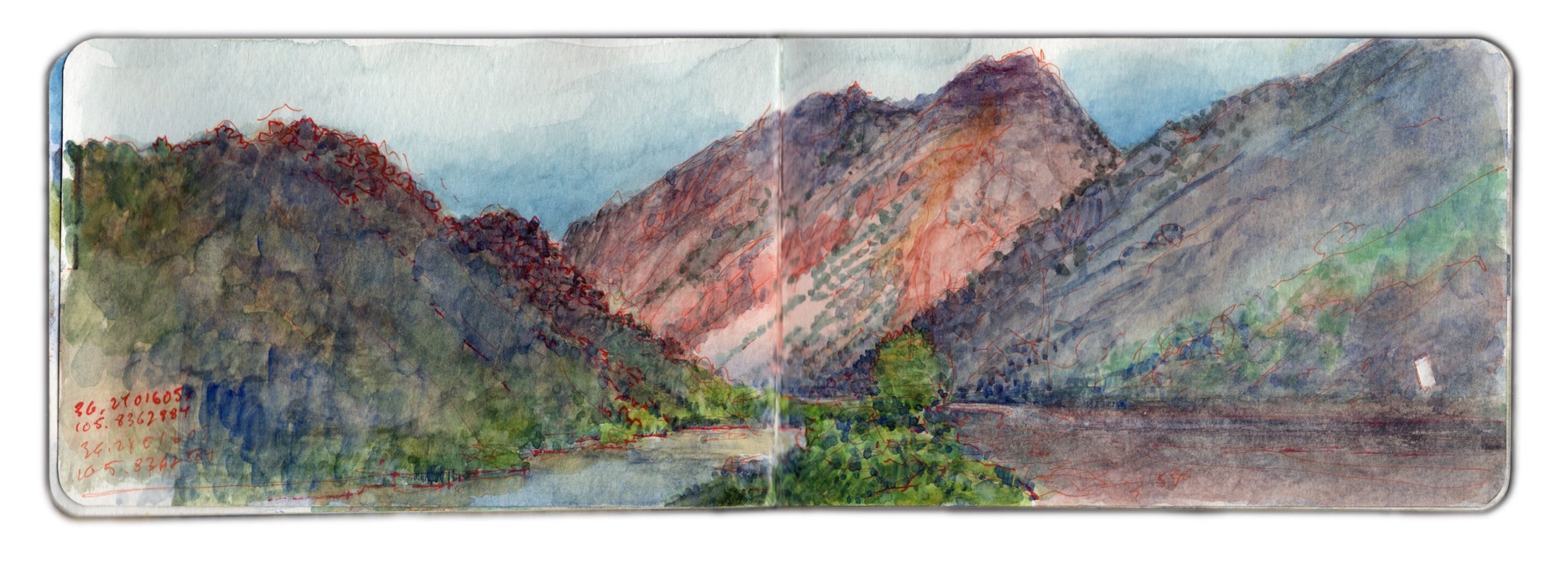
May 6, 2019. Upriver from Embudo Station. 36.2402 x 105.8366. 46 degrees NW. 2436-2450, NM-68, Taos.

Heading southwest on state highway 68, one passes a series of roadside pull-offs frequented by anglers and shutterbugs. On the outbound drive, I had made a note of the steep inclined mountain between Pilar and Embudo, framed between two sloping hills. A few miles downstream is a pair of volcanic plugs, between which Rio Embudo flows through a wooded gap, into the Rio Grande. The place-name in Spanish means “bottleneck”. Nearby on March 30, 1854, a young, bigoted lieutenant rashly led two companies of the First Regiment, U.S. Dragoons into an ambush. Jicarilla Apache and Ute warriors engaged the dragoons in a pitched, four-hour battle, forcing the soldiers to withdraw to Rancho de Taos. Considerable losses were suffered on both sides.
Native victory was short-lived. Eight days later, with Kit Carson serving as guide, a detachment of the 2nd U.S, Dragoons under Lieutenant Philip St. George Cooke fell upon the war-party at Ojo Caliente. Many who survived the attack perished from exposure. In a note of irony, as the battle raged, Carson had been on a mission to offer the native combatants rations and humanitarian aid. The present-day village was established in 1881, as a watering station for the Chili Line of the Denver and Rio Grande Western Railroad. Seven years later the hamlet was selected by explorer John Wesley Powell as a stream-gauging station for the U.S. Geological Survey. Embudo Historic District was added to the National Register of Historic Places in 1979, coincidentally the year of my first visit to New Mexico.

NOW AVAILABLE: SKETCHBOOK TRAVELER by James L. McElhinney (c) 2020. Schiffer Publishing).


AVAILABLE September 27, 2022

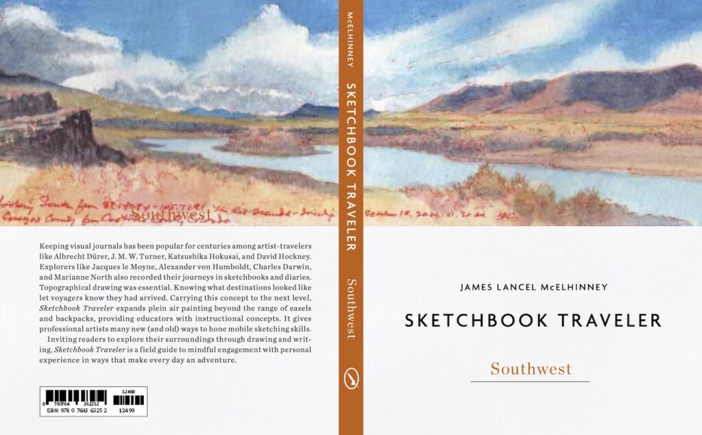
Sketchbook Traveler. Southwest was due to be released in May, but due to supply chain issues related to the Covid pandemic, the first edition (which has been printed overseas) is due to arrive in late summer. Following up on the success of Sketchbook Traveler: Hudson Valley, volume 2 in this trilogy explores  the American Southwest from New Mexico to the Mojave Desert in journal-paintings and field notes by the author. Conceived as a backpacker’s field-guide and coffee-table art book, this compact volume includes lessons in print; a “why-to” guide to augmenting ubiquitous photographic devices.  Blank pages scattered with inspirational quotes are provided for keeping one’s own traveler’s sketchbook. Pre-order here: LINK

Also:


Order your copy of the book here: LINK

For information about Needlewatcher Editions, write to

ed******@ne***********.com


Needlewatcher Editions. PO Box 233. Essex, New York. 12936-0233. (347) 266-5652
Copyright James Lancel McElhinney (c) 2020 Texts and images may be reproduced (with proper citation) by permission of the author. To enquire, send a request to


ed******@ne***********.com


Copyright James Lancel McElhinney (c) 2020 Texts and images may be reproduced (with proper citation) by permission of the author. To enquire, send a request to

ed******@ne***********.com


APRIL 3, 2020. QUARANTEAM TRAVEL. DISPATCH #3

Moving into the darkest days of the pandemic, we all patiently wait for the crisis to pass. Last Wednesday I published the first in a series of daily website blog-posts, of writings and artworks that celebrate personal mobility, in pursuit of mindful engagements with history, nature and the environment. In relation to a finished painting, or an essay, this process is no less a work of art than is the tree to the fruit it bears. In a sense, this practice may be ceremonial, acts of reverence, in beholding the world around us. Offered as messages of hope and solidarity, these posts will appear every day, until these dark days are behind us.

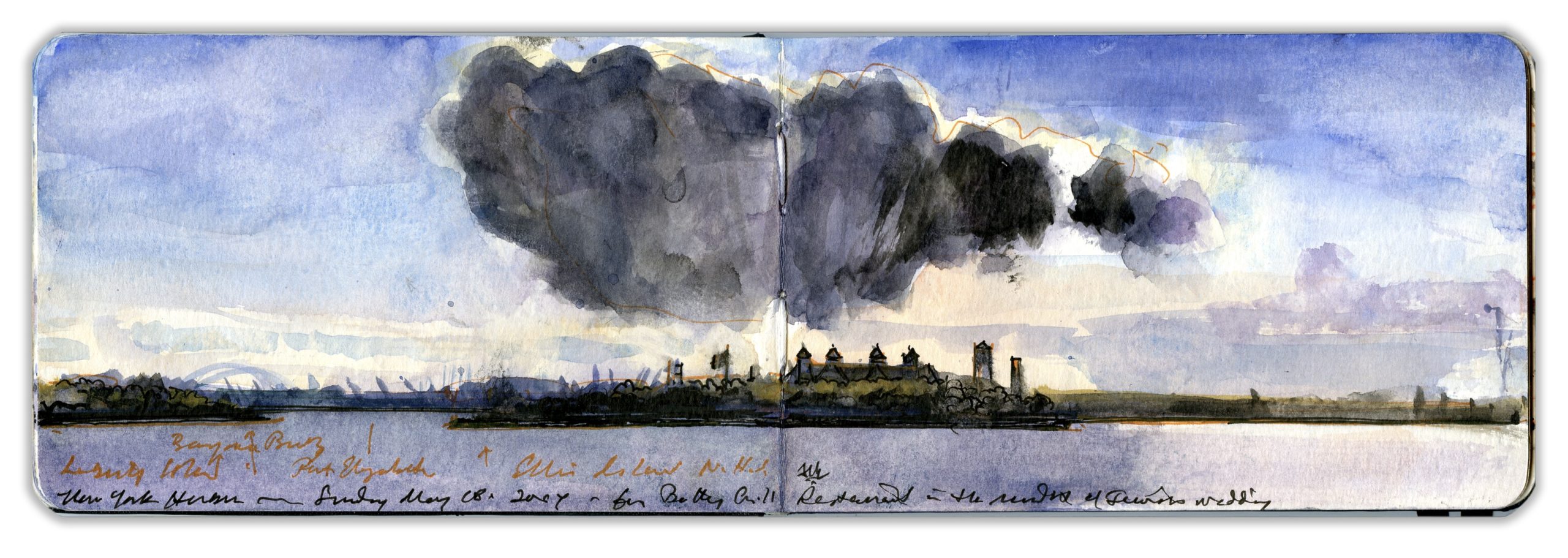
Oyster Island, also known as Ellis Island, was first fortified in 1795, in preparation for what came to be known as the Quasi-War with France. Acquired by the federal government in 1808, a twenty-gun battery was established, which in concert with the guns of Castle Williams on Governor’s Island and Castle Clinton at the Battery in lower Manhattan, created a kill-zone at the mouth of the Hudson River. While it saw no action during the War of 1812, the island served as a prisoner-of-war camp during the conflict. In 1861 Fort Gibson was decommissioned and repurposed as a naval weapons depot. By 1890 the flood of immigrants into New York City had exceeded the capacity of Castle Garden. The navy vacated Ellis Island. A new immigration inspection station opened its doors in 1892. It remained in service until 1954. More than twelve million arrivals passed through its gates to become permanent residents and citizens of the United States. Today the site is part of Statue of Liberty National Monument, and is accessible only by water.
This painting was made in Battery Park, looking across New York harbor, from beside the East Coast Memorial, honoring members of the U.S. Merchant Marine and Army Transport Service who died in coastal waters during the Second World War. Hovering above Ellis Island, a dark cloud might resonate with what many are feeling at this moment in time.

NOE AVAILABLE: SKETCHBOOK TRAVELER by James L. McElhinney (c) 2020. Schiffer Publishing).

AVAILABLE September 27, 2022

Sketchbook Traveler. Southwest was due to be released in May, but due to supply chain issues related to the Covid pandemic, the first edition (which has been printed overseas) is due to arrive in late summer. Following up on the success of Sketchbook Traveler: Hudson Valley, volume 2 in this trilogy explores  the American Southwest from New Mexico to the Mojave Desert in journal-paintings and field notes by the author. Conceived as a backpacker’s field-guide and coffee-table art book, this compact volume includes lessons in print; a “why-to” guide to augmenting ubiquitous photographic devices.  Blank pages scattered with inspirational quotes are provided for keeping one’s own traveler’s sketchbook. Pre-order here: LINK

Also:


Order your copy of the book here: LINK


For information about Needlewatcher Editions, write to

ed******@ne***********.com


Needlewatcher Editions. PO Box 233. Essex, New York. 12936-0233. (347) 266-5652
Copyright James Lancel McElhinney (c) 2020 Texts and images may be reproduced (with proper citation) by permission of the author. To enquire, send a request to


ed******@ne***********.com


APRIL 2, 2020

As New York moves into the darkest days of the pandemic, we all patiently wait for the crisis to pass. Yesterday, I published the first in a series of daily website blog-posts, of writings and artworks that celebrate personal mobility, in pursuit of mindful engagements with history, nature and the environment. In relation to a finished painting, or an essay, this process is no less a work of art than is the tree to the fruit it bears. In a sense, this practice may be ceremonial, acts of reverence, in beholding the world around us. Offered as messages of hope and solidarity, these posts will appear every day, until this pestilence subsides.


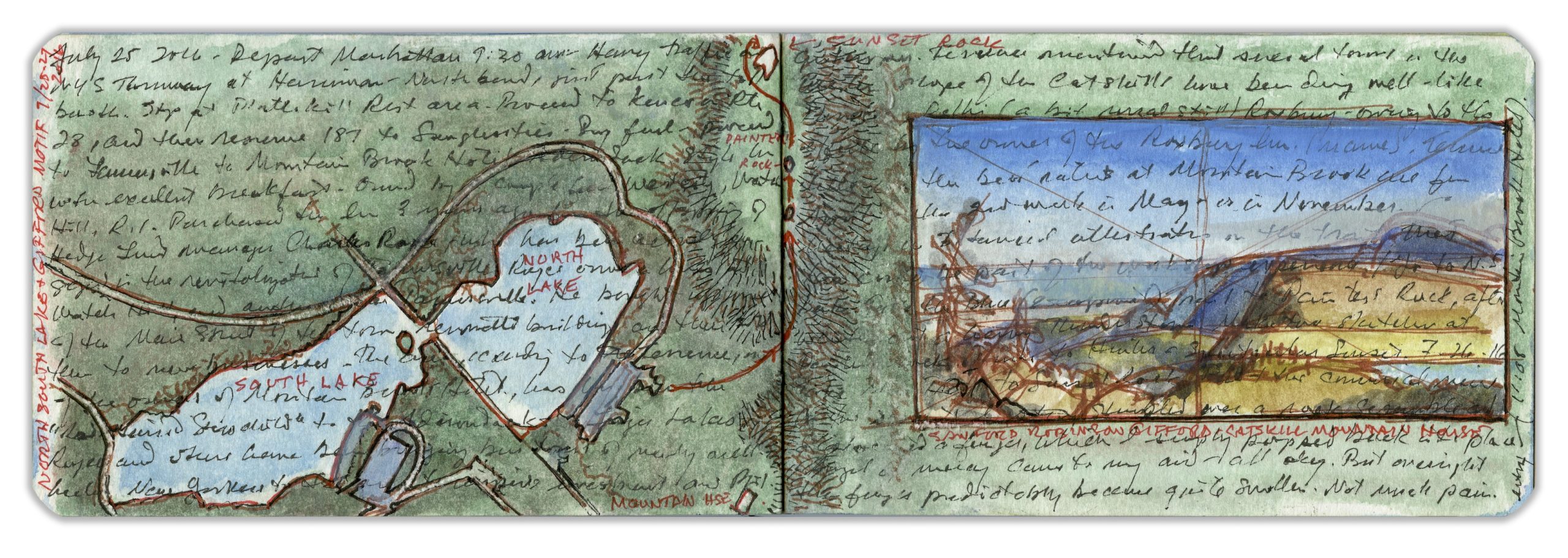
North-South Lake. Hudson Valley Sketchbook. 2016. Collection Hudson River Museum, Yonkers, New York

Extending westward from the Catskill Escarpment, twin lakes rest in a broad vale between North and South Mountains. On its eastern rim, the Catskill Mountain House site is now a wide grassy ledge. Westward, the land rises toward Tannersville. Before European invaders built settlements in the mountains, indigenous farmers lived in the bottomlands, using the heights as their hunting-grounds. Dutch expansion into the region triggered resistance, which escalated into warfare. Crops were destroyed. Settlements scattered, clearing the way for modern economies. Exploring the mountains in the 1740s, Philadelphia naturalist John Bartram discovered new plant species. At age fourteen his son Billy had demonstrated a passion for drawing. In 1755 Bartram writes: “I design to set Billy to draw all our turtles with remarks, as he has time, which is only on Seventh days in the afternoon, and First-day mornings; for he is constantly kept to school to learn Latin and French.”
Father and son had traveled to the Catskills two years prior, visiting North-South Lake. Attracted to a large growth of Auricularia auricula-judae, the boy was about to test it with his foot when his father pulled him back, away from a coiled rattlesnake. Under protest from both father and son, their guide put the creature to death.
Having made notes on site, I added a map in overlay, and beside it a thumbnail of Sanford Gifford’s view from Sunset Rock, which I had visited earlier in the day. Over the years I have come to regard any location on the surface of the earth as a palimpsest, not just as living things clinging to the rocky crust of a molten orb, but as residue of our memories and desires inscribed upon the terrain.

(A preview of SKETCHBOOK TRAVELER by James L. McElhinney (c) 2020. Schiffer Publishing).

Copyright James Lancel McElhinney (c) 2020 Texts and images may be reproduced (with proper citation) by permission of the author. To enquire, send a request to

ed******@ne***********.com