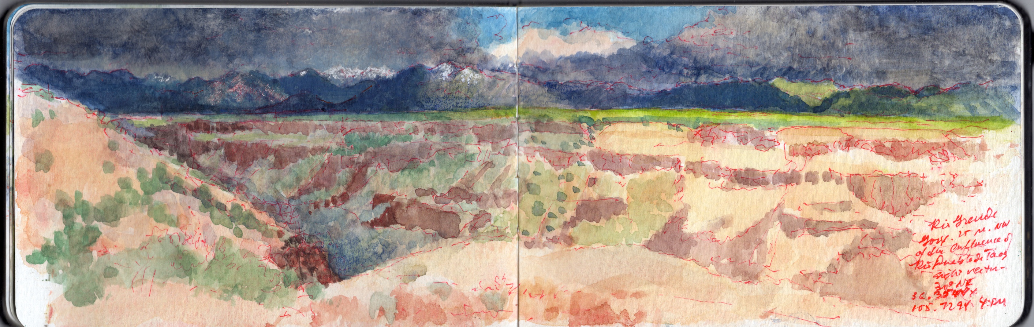
May 8, 2019. Near the Trail-head above Taos Junction Bridge. 30 degrees NE.36.3544 x 105.7294. 2-4pm
May 8, 2019. Wake early, make journal entries, posting them on social media. Simple breakfast. Work in the studio. Decide to try to produce a concertina book. Call Artisan, ordering cut foam-core to serve as (2 each) supports of the books (10 x 48”), and large works on paper (22 x 30”). Set out to work at White Rock Canyon, but dark clouds over the Jemez Caldera cause me to rethink my plan. Instead I drive pas Black Mesa, taking photos for reference. From there I follow the river to Ohkay Owingeh (San Juan Pueblo), crisscrossing the river. Chary of setting up in Indian land, I follow the Chama River for a distance before heading toward Ojo Caliente.
The area is agricultural. The village appears to survive off the revenue from guests staying at the eponymous spa and resort, surrounded by a modest number of satellite B&Bs and restaurants. I do not tarry A long mesa rises more than a thousand feet to my right (east). Continuing north on US285 toward Antonito, the land rises gradually, until the roadbed is level with the plain atop the mesa. I turn right onto NM567, passing a number of US Forest Service roads. I pull into one reddish dirt road, check my location and take a few photos looking south, toward the mouth of Rio Grande Gorge. Mental note. Rent a 4WD off-road vehicle. Ten miles to Canada de Embudo. Check the map later. Returning to NM567, I guide my Subaru eastward. The road seems to have been laid down onto the terrain with a straight-edge, running from west to east.
The land falls away to the south. Red soil gives way to sharp gravel and dark rocks. All is covered by the familiar scattering of sage and pinyon, a bushy sea of celadon and jade. Gullies widen into arroyos, revealing rocky layers like icing on a cake, breaking through the soil.
Suddenly, the drawing-board that plotted my course sends the two-lane blacktop into a ninety-degree turn to the left. Black and yellow zebra signs proclaim the event. I pause, look at the map. Country Road C-115 carries on to the north, toward US64 and the gorge high bridge.
State road 567 turns right, to the southeast, winding its way down to Taos Junction Bridge.
I follow the road, as it slowly descends along a gentle grade. Ahead can be seen the rocky walls of the Rio Grande Gorge. A few hundred yards to the left I see a group of parked cars, most with rooftop carriers. Just before the main road plunges down a series of OMG switchbacks, I turn left onto a dirt road, which leads to one of the western rim trailheads. I park alongside an SUV and walk toward the rim. Following a brief reconnaissance, I set up to paint. Selecting a sight-vector of 30 degrees northeast, I open the book and get to work. Measuring distances, gauging relative spatial depth, and mapping different features and landmarks, I find myself drawn to the simplicity of the composition—a dark leftward arrow, underlining the upper band of snow-capped mountains. Below the horizontal, abstract patterns of rock-layers and vegetation remind me why this very terrain had so enchanted Stuart Davis, Marsden Hartley and Georgia O’Keeffe. A thunderclap sounds behind me. Towering off to the west, black clouds seem to stride on graphite slabs—diaphanous curtains of promiscuous downpours. Scattered drops strike the dusty soil, like the shotgun pellets and .22 bullet-holes that pepper an interpretive sign at the parking-area. The storm moves eastward, four or five miles to the north. Native artists set up in the parking-lot next to the bridge on US64 must be scrambling to cover their tables, or put away their wares before the deluge arrives. Suddenly, bright sunshine warms my back. Shadows darken. Edges sharpen. The northern stretch of the canyon is thrown into darkness. Across the chasm, the vertiginous layer-cake effect of volcanic rock and alluvial sediment pales in the sunlight. Umbrageous clouds shroud the mountains beyond. Too much to absorb in one sitting, or to commit to paper with pigment, water and weasel hair.
One speaks of the Sublime, but talk is cheap. One cannot comprehend it, without knowing fear and awe. Speaking at a conference in New York in the nineties, I shared that going into the wild, I sometimes wore a revolver on my hip—as an argument against feral dogs, rabid mammals and venomous snakes. Sitting in the audience, another presenter—the late Martha Mayer Erlebacher—raised her hand and commented. “I love it. Art as a life or death experience!”
Note to self. Good field kit for wild places. Orvis bush shirt, Outback Trading Co. or Filson crushable waxed cotton round-hat. Drake neck-scarf/cravat. Duluth Trading company travel-vest. Nylon cargo pants. Filson belt. Woolen socks (all seasons). Danner hiking boots, Wolverine oiled leather 1000-Mile boots, or knee-length Chippewa snake-boots (for protection against briars and venomous reptiles). Handmade belt-knife. Compass. Brass-tipped Yew walking-stick with wrought-iron rams-head Branscombe Forge, Devon. Kaweco brass pencil (port-crayon) and fountain pen. Sakura Micron colored pens, Watercolor travel-kit (Schmincke or Sennelier, enameled steel, with integral water-flask. Safety razor. Moleskine watercolor journal. Pocket notebook. Maps. Mobile phone. A quart of drinking water. Sunglasses. Sunscreen. Insect repellent. Travel protocols. When venturing out alone, know where you are heading. Let someone else know. Keep a log.
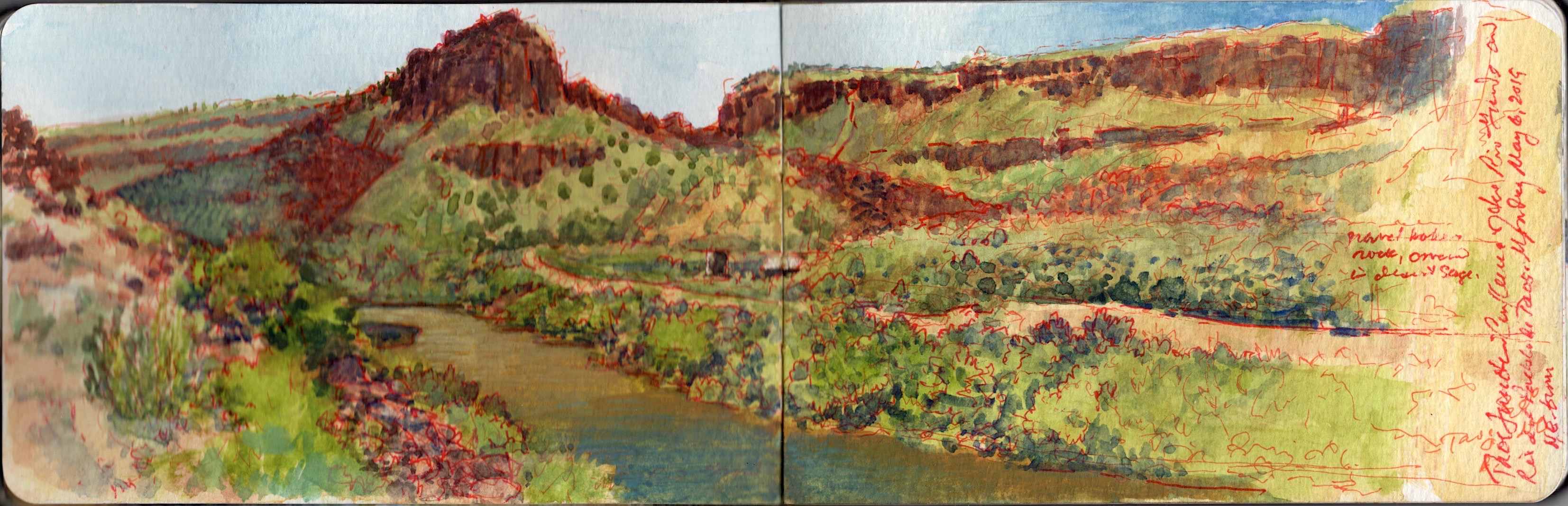
May 6, 2019. 59 degrees ENE. 36.3354 x 105.7346. Taos Junction Bridge is a Pratt riveted through-truss span 150 yards below the confluence of the Rio Grande del Norte and Rio Pueblo de Taos, flowing through a gorge seen to the right in this image. The confluence is undramatic, as Rio Taos joins the great river, sheltered by riverbanks covered with pinyon and sage. This might be considered the mouth of the Rio Grande Gorge, even though the river has another twenty-one miles to go before debouching onto a wider to flood-plain at Velarde. A dirt road on the left bank of the river winds its way up Taos gorge to blacktop on the plain above. From the western bridge-head, another unpaved road sans guard-rails climbs through a series of OMG switchbacks to become County Road C-115, meeting US64 just west of the high bridge crossing the Rio Grande. Near the confluence is a series of campgrounds, small buildings; restrooms and state utility sheds. Less than a mile downriver, Orilla Verde recreation area offers a wider menu of amenities. Just below the bridge, is aa parking area and boat ramp. A car carrying two kayaks rolled into the dusty patch of bare soil. Within minutes, they were on the river and away. As record snowpack in Colorado last winter melt, the river rises. In a week or two, or maybe tomorrow, it might be licking the girders under the roadbed. A woman walked onto the bridge, turned toward the confluence and took a few pictures. Two men, who seemed to be intimate friends, walked behind me with a dog on a leash, turning onto the trail that skirts the right bank of the river. One of the gents wore a porkpie hat and plaid shirt of the lumbersexual hipster. The other, taller fellow was the affectless beau-ideal of sartorial practicality; ball-cap, light jacket and jeans. Banging on about finance and investment, they followed the dog out of earshot, into the rock-fall and pinyon. Driving back to Pilar and NM68, I returned to the audiobook version of Richard Powers’s The Overstory. Suddenly, the radio squawked three times, followed by a flash-flood warning. By then I was back on the main road, traveling south toward Española.

May 6, 2019. Upriver from Embudo Station. 36.2402 x 105.8366. 46 degrees NW. 2436-2450NM-68, Taos.
Heading southwest on state highway 68, one passes a series of roadside pull-offs frequented by anglers and shutterbugs. On the outbound drive, I had made a note of the steep inclined mountain between Pilar and Embudo, framed between two sloping hills. A few miles downstream is a pair of volcanic plugs, between which Rio Embudo flows through a wooded gap, into the Rio Grande. The place-name in Spanish means “bottleneck”. Nearby on March 30, 1854, a young, bigoted lieutenant rashly led two companies of the First Regiment, U.S. Dragoons into an ambush. Jicarilla Apache and Ute warriors engaged the dragoons in a pitched, four-hour battle, forcing the soldiers to withdraw to Rancho de Taos. Considerable losses were suffered on both sides.
Native victory was short-lived. Eight days later, with Kit Carson serving as guide, a detachment of the 2nd U.S, Dragoons under Lieutenant Philip St. George Cooke fell upon the war-party at Ojo Caliente. Many who survived the attack perished from exposure. In a note of irony, as the battle raged, Carson had been on a mission to offer the native combatants rations and humanitarian aid. The present-day village was established in 1881, as a watering station for the Chili Line of the Denver and Rio Grande Western Railroad. Seven years later the hamlet was selected by explorer John Wesley Powell as a stream-gauging station for the U.S. Geological Survey. Embudo Historic District was added to the National Register of Historic Places in 1979, the year of my first visit to New Mexico.
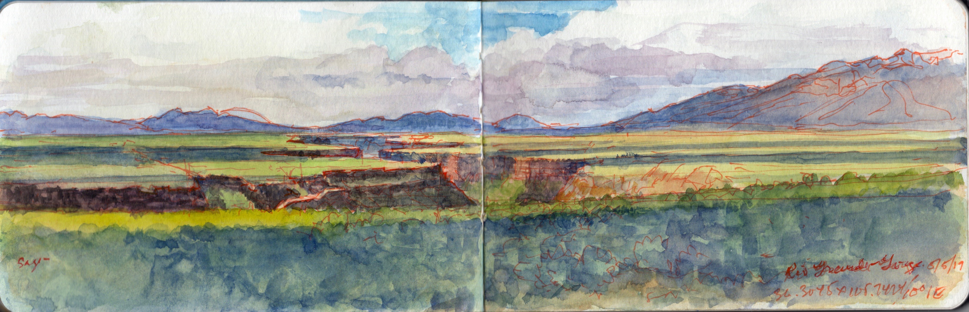
Roadside vista. Rio Grande Gorge from NM68. 10.0000 degrees NE. from 36.4105 x 105.2424. May 5, 2019.
Two hikers climb over the wire fence hundred behind me (south). Motorists pull over and snap photos. Almost every one of them hold their phone or camera, arms fully extended above their heads, as if they could peer into the nearly thousand-foot ditch two miles away. Speeding past, drivers honk and wave at me.
Taos Valley is actually the southernmost extremity of the San Luis basin, the northern end of the Rio Grande Rift. The two distant peaks are volcanic domes. Ute Mountain lies dead ahead, with Antonio Peak to the left. Alluvial sediment, laid down over volcanic ash and lava flows, is crossed by the river through a deep gorge. While the waters are navigable, they tend to be treacherous at this time of year. Record snowpack this past winter promise dramatic floodwaters later this spring. The plain is covered in Desert Sage (Salvi dorrii) and Pinyon Pine (Pinus monophylla). Taos Pueblo is at the foot of the mountains to the far right. Across the river, County Road C-8-115 descends to Taos Junction Bridge, just below the confluence of Rio Pueblo de Taos. The road continues south through Orilla Verde and Pilar, terminating at NM68
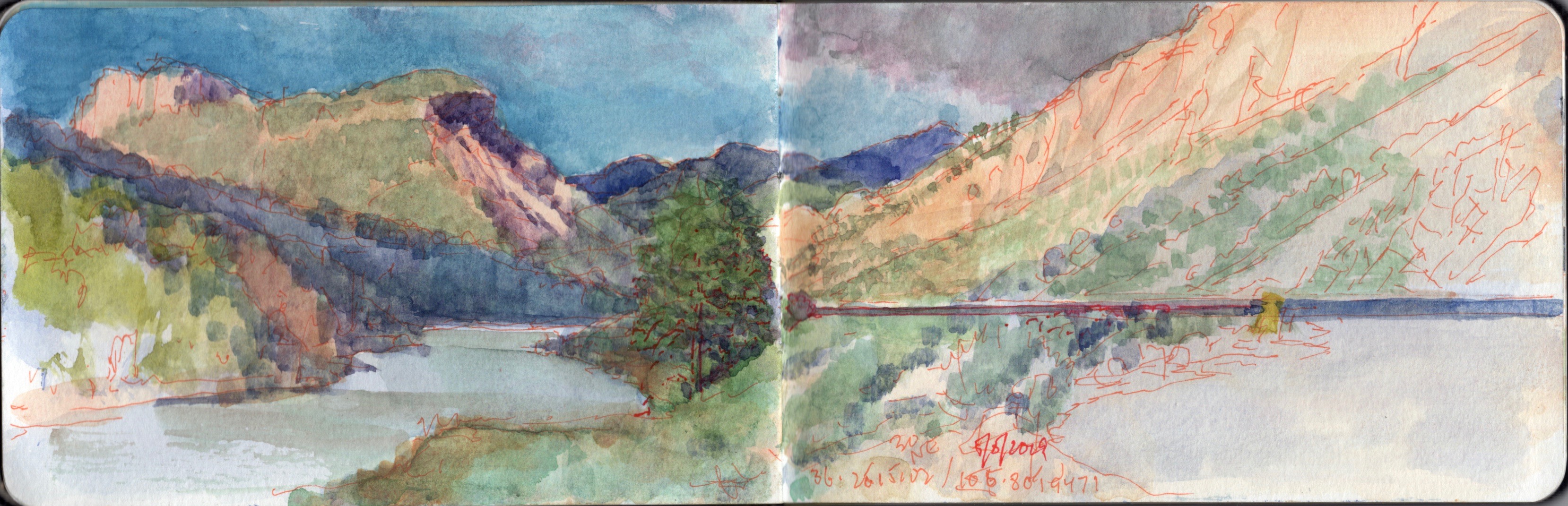
Roadside Vista. Below Pilar, Route NM68. 30 degrees NE from 36.2515102 x 105.801947.May 5, 2019
Named for the columnar mountain that rises above it, Nuestra Senora de Pilar stands on the historic site of an Apache village burned by Diego de Vargas during the Reconquista of 1684. The riverbank settlement is contained within the Spanish land-grant of Cieneguilla, awarded to twenty-five families in 1795. Taos County Road C-115 runs through the village, then upriver through Orilla Verde to Taos Junction Bridge. Clinging to the vertiginous walls of the gorge, the road climbs to the rim via a series of hair-raising switchbacks. Turning northward, it crosses the plain, intersecting US64 just west of the Rio Grande Gorge Bridge. Pilar today is home to the Rio Grande Gorge visitor center, café, river-guide and rafting-tour company.